Salima geodata
Salima (Central Region) is a seat of a second-order administrative division; located in Malawi in Africa/Blantyre (GMT+2) time zone. With population of 30,052 people, there are 7 cities with bigger population in this country. Compared to other cities in Malawi, 62.9% of cities are located further ↓South; 57.1% of cities are located further →East and 74.3% of cities have higher elevation than Salima. Note1


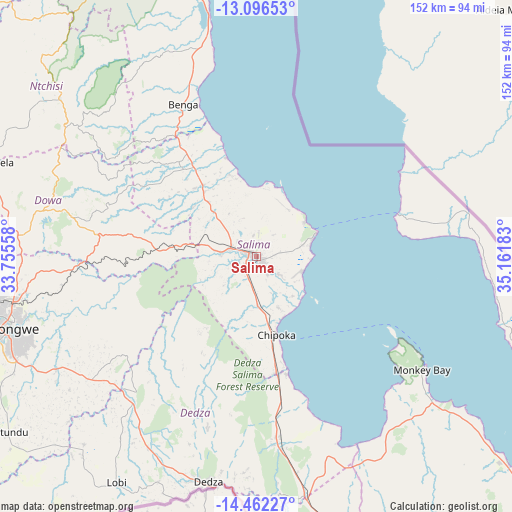
Salima GPS coordinates[2]
13° 46' 49.44" South, 34° 27' 31.32" East
| Map corner | latitude | longitude |
|---|---|---|
| Upper-left | -13.09653°, | 33.75558° |
| Center: | -13.7804°, | 34.4587° |
| Lower-right: | -14.46227°, | 35.16183° |
| Map W x H: | 151.9×151.9 km | = 94.4×94.4mi |
| max Lat: | -9.70237° ⇑37.1% North |
| Salima: | -13.7804° |
| min Lat: | ⇓62.9% South -16.91995° |
| min Long | Salima | max Long |
| 32.88019° | 34.4587° | 35.65067° |
| W 42.9%⇐ | ⇒57.1% E |
Elevation
Elevation of Salima is 512 m = 1680 ft, and this is 356.7 m = 1170 ft below average elevation for this country.
| Max E: |
1608 m = 5276 ft | 74.3% |
| Avg. | 868.7 m = 2850 ft | |
| Salima | 512 m = 1680 ft | |
Min E: |
55 m = 180 ft | 25.7% |
See also: Malawi elevation on elevation.city.
Geographical zone
Salima is located in South Torrid zone (between Equator and Tropic of Capricorn). Distance of this Southern Tropic circle is 1073.7 km =667.2 mi to South.| Distance of | km | miles | from Salima |
|---|---|---|---|
| Equator | 1532.2 | 952.1 | to North |
| Tropic Capricorn | 1073.7 | 667.2 | to South |
| Antarctic Circle | 5868.9 | 3646.8 | to South |
| South Pole | 8474.8 | 5266 | to South |


Nearby cities:
15 places around Salima: (largest is in red/bold)
• Balaka
143.7 km =89.3 mi,  158°
158°
• Chipoka
24.5 km =15.2 mi,  165°
165°
• Dedza
67.8 km =42.1 mi,  191°
191°
• Dowa
58 km =36 mi,  284°
284°
• Kasungu
134.3 km =83.5 mi,  308°
308°
• Lilongwe
75.4 km =46.9 mi,  254°
254°
• Liwonde
165.1 km =102.6 mi,  150°
150°
• Machinga
179 km =111.2 mi, 149°
• Mangochi
116.5 km =72.4 mi,  131°
131°
• Mchinji
170.5 km =105.9 mi,  269°
269°
• Monkey Bay
59.7 km =37.1 mi,  124°
124°
• Mponela
82.4 km =51.2 mi,  289°
289°
• Nkhotakota
96.5 km =60 mi,  349°
349°
• Ntcheu
117.2 km =72.8 mi, 170°
• Ntchisi
65.1 km =40.5 mi,  295°
295°
Sources, notices
• [Note1] Compared only with cities in Malawi existing in our database
• [Src1] Map data: © OpenStreetMap contributors (CC-BY-SA)
• [Src2] Other city data from geonames.org with taken over terms of usage.
• [Src3] Geographical zone / Annual Mean Temperature by Robert A. Rohde @ Wikipedia
