Livingstonia geodata
Livingstonia (Northern Region) is a populated place; located in Malawi in Africa/Blantyre (GMT+2) time zone. With population of 5,552 people, there are 28 cities with bigger population in this country. Compared to other cities in Malawi, 94.3% of cities are located further ↓South; 68.6% of cities are located further →East and 91.4% of cities have lower elevation than Livingstonia. Note1


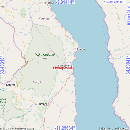
Livingstonia GPS coordinates[2]
10° 36' 21.672" South, 34° 6' 22.608" East
| Map corner | latitude | longitude |
|---|---|---|
| Upper-left | -9.91414°, | 33.40316° |
| Center: | -10.60602°, | 34.10628° |
| Lower-right: | -11.29634°, | 34.80941° |
| Map W x H: | 153.7×153.7 km | = 95.5×95.5mi |
| max Lat: | -9.70237° ⇑5.7% North |
| Livingstonia: | -10.60602° |
| min Lat: | ⇓94.3% South -16.91995° |
| min Long | Livingstonia | max Long |
| 32.88019° | 34.10628° | 35.65067° |
| W 31.4%⇐ | ⇒68.6% E |
Elevation
Elevation of Livingstonia is 1350 m = 4429 ft, and this is 481.3 m = 1579 ft above average elevation for this country.
| Max E: |
1608 m = 5276 ft | 8.6% |
| Livingstonia | 1350 m 4429 ft | |
| Avg. | 868.7 m = 2850 ft | |
Min E: |
55 m = 180 ft | 91.4% |
See also: Malawi elevation on elevation.city.
Geographical zone
Livingstonia is located in South Torrid zone (between Equator and Tropic of Capricorn). Distance of Equator is 1179.3 km =732.8 mi to North.| Distance of | km | miles | from Livingstonia |
|---|---|---|---|
| Equator | 1179.3 | 732.8 | to North |
| Tropic Capricorn | 1426.6 | 886.4 | to South |
| Antarctic Circle | 6221.9 | 3866.1 | to South |
| South Pole | 8827.8 | 5485.3 | to South |


Nearby cities:
15 places around Livingstonia: (largest is in red/bold)
• Chitipa
135.9 km =84.4 mi,  317°
317°
• Dowa
339.4 km =210.9 mi,  183°
183°
• Karonga
77.2 km =48 mi,  345°
345°
• Kasungu
278.3 km =172.9 mi,  194°
194°
• Likoma
176.2 km =109.5 mi,  157°
157°
• Lilongwe
375.3 km =233.2 mi, 185°
• Mchinji
379.1 km =235.6 mi,  200°
200°
• Mponela
327.8 km =203.7 mi, 186°
• Mzimba
154.1 km =95.8 mi, 200°
• Mzuzu
96 km =59.7 mi, 185°
• Nkhata Bay
113.1 km =70.3 mi,  169°
169°
• Nkhotakota
258.9 km =160.9 mi, 175°
• Ntchisi
325.5 km =202.3 mi, 183°
• Rumphi
53.3 km =33.1 mi,  210°
210°
• Salima
355 km =220.6 mi, 173°
Sources, notices
• [Note1] Compared only with cities in Malawi existing in our database
• [Src1] Map data: © OpenStreetMap contributors (CC-BY-SA)
• [Src2] Other city data from geonames.org with taken over terms of usage.
• [Src3] Geographical zone / Annual Mean Temperature by Robert A. Rohde @ Wikipedia
