Kasungu geodata
Kasungu (Central Region) is a seat of a second-order administrative division; located in Malawi in Africa/Blantyre (GMT+2) time zone. With population of 42,555 people, there are 4 cities with bigger population in this country. Compared to other cities in Malawi, 74.3% of cities are located further ↓South; 94.3% of cities are located further →East and 60% of cities have lower elevation than Kasungu. Note1


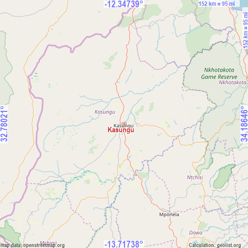
Kasungu GPS coordinates[2]
13° 1' 59.988" South, 33° 28' 59.988" East
| Map corner | latitude | longitude |
|---|---|---|
| Upper-left | -12.34739°, | 32.78021° |
| Center: | -13.03333°, | 33.48333° |
| Lower-right: | -13.71738°, | 34.18646° |
| Map W x H: | 152.3×152.3 km | = 94.6×94.6mi |
| max Lat: | -9.70237° ⇑25.7% North |
| Kasungu: | -13.03333° |
| min Lat: | ⇓74.3% South -16.91995° |
| min Long | Kasungu | max Long |
| 32.88019° | 33.48333° | 35.65067° |
| W 5.7%⇐ | ⇒94.3% E |
Elevation
Elevation of Kasungu is 1051 m = 3448 ft, and this is 182.3 m = 598 ft above average elevation for this country.
| Max E: |
1608 m = 5276 ft | 40% |
| Kasungu | 1051 m 3448 ft | |
| Avg. | 868.7 m = 2850 ft | |
Min E: |
55 m = 180 ft | 60% |
See also: Kasungu elevation on elevation.city.
Geographical zone
Kasungu is located in South Torrid zone (between Equator and Tropic of Capricorn). Distance of this Southern Tropic circle is 1156.7 km =718.7 mi to South.| Distance of | km | miles | from Kasungu |
|---|---|---|---|
| Equator | 1449.2 | 900.5 | to North |
| Tropic Capricorn | 1156.7 | 718.7 | to South |
| Antarctic Circle | 5952 | 3698.4 | to South |
| South Pole | 8557.9 | 5317.6 | to South |


Nearby cities:
15 places around Kasungu: (largest is in red/bold)
• Chipoka
154.4 km =95.9 mi,  133°
133°
• Dedza
175.4 km =109 mi,  148°
148°
• Dowa
84.7 km =52.6 mi,  144°
144°
• Likoma
173.1 km =107.6 mi,  51°
51°
• Lilongwe
108.9 km =67.7 mi,  162°
162°
• Mchinji
107.2 km =66.6 mi,  217°
217°
• Monkey Bay
193.9 km =120.5 mi, 126°
• Mponela
62 km =38.5 mi, 153°
• Mzimba
126.6 km =78.7 mi,  5°
5°
• Mzuzu
183.8 km =114.2 mi,  18°
18°
• Nkhata Bay
181.3 km =112.7 mi,  28°
28°
• Nkhotakota
88.9 km =55.2 mi,  82°
82°
• Ntchisi
72.1 km =44.8 mi, 139°
• Rumphi
227.7 km =141.5 mi, 10°
• Salima
134.3 km =83.5 mi, 128°
Sources, notices
• [Note1] Compared only with cities in Malawi existing in our database
• [Src1] Map data: © OpenStreetMap contributors (CC-BY-SA)
• [Src2] Other city data from geonames.org with taken over terms of usage.
• [Src3] Geographical zone / Annual Mean Temperature by Robert A. Rohde @ Wikipedia
