Mzimba geodata
Mzimba (Northern Region) is a seat of a second-order administrative division; located in Malawi in Africa/Blantyre (GMT+2) time zone. With population of 19,308 people, there are 12 cities with bigger population in this country. Compared to other cities in Malawi, 82.9% of cities are located further ↓South; 91.4% of cities are located further →East and 88.6% of cities have lower elevation than Mzimba. Note1


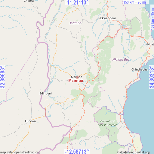
Mzimba GPS coordinates[2]
11° 54' 0" South, 33° 36' 0" East
| Map corner | latitude | longitude |
|---|---|---|
| Upper-left | -11.21113°, | 32.89688° |
| Center: | -11.9°, | 33.6° |
| Lower-right: | -12.58713°, | 34.30313° |
| Map W x H: | 153×153 km | = 95.1×95.1mi |
| max Lat: | -9.70237° ⇑17.1% North |
| Mzimba: | -11.9° |
| min Lat: | ⇓82.9% South -16.91995° |
| min Long | Mzimba | max Long |
| 32.88019° | 33.6° | 35.65067° |
| W 8.6%⇐ | ⇒91.4% E |
Elevation
Elevation of Mzimba is 1339 m = 4393 ft, and this is 470.3 m = 1543 ft above average elevation for this country.
| Max E: |
1608 m = 5276 ft | 11.4% |
| Mzimba | 1339 m 4393 ft | |
| Avg. | 868.7 m = 2850 ft | |
Min E: |
55 m = 180 ft | 88.6% |
See also: Malawi elevation on elevation.city.
Geographical zone
Mzimba is located in South Torrid zone (between Equator and Tropic of Capricorn). Distance of this Southern Tropic circle is 1282.8 km =797.1 mi to South.| Distance of | km | miles | from Mzimba |
|---|---|---|---|
| Equator | 1323.2 | 822.2 | to North |
| Tropic Capricorn | 1282.8 | 797.1 | to South |
| Antarctic Circle | 6078 | 3776.7 | to South |
| South Pole | 8683.9 | 5395.9 | to South |


Nearby cities:
15 places around Mzimba: (largest is in red/bold)
• Chitipa
247 km =153.5 mi,  351°
351°
• Dowa
198.4 km =123.3 mi,  169°
169°
• Karonga
221.7 km =137.8 mi,  9°
9°
• Kasungu
126.6 km =78.7 mi,  185°
185°
• Likoma
124.7 km =77.5 mi,  98°
98°
• Lilongwe
230.7 km =143.4 mi, 174°
• Livingstonia
154.1 km =95.8 mi,  20°
20°
• Mchinji
225 km =139.8 mi,  200°
200°
• Mponela
182.1 km =113.2 mi,  175°
175°
• Mzuzu
66.6 km =41.4 mi,  43°
43°
• Nkhata Bay
82 km =51 mi,  66°
66°
• Nkhotakota
137 km =85.1 mi,  146°
146°
• Ntchisi
184.2 km =114.5 mi, 169°
• Rumphi
101.9 km =63.3 mi, 15°
• Salima
228.9 km =142.2 mi,  156°
156°
Sources, notices
• [Note1] Compared only with cities in Malawi existing in our database
• [Src1] Map data: © OpenStreetMap contributors (CC-BY-SA)
• [Src2] Other city data from geonames.org with taken over terms of usage.
• [Src3] Geographical zone / Annual Mean Temperature by Robert A. Rohde @ Wikipedia
