Kamba geodata
Kamba (Kebbi) is a seat of a second-order administrative division; located in Nigeria in Africa/Lagos (GMT+1) time zone. With population of 25,568 people, there are 174 cities with bigger population in this country. Compared to other cities in Nigeria, 82.5% of cities are located further ↓South; 94.6% of cities are located further →East and 65.1% of cities have higher elevation than Kamba. Note1


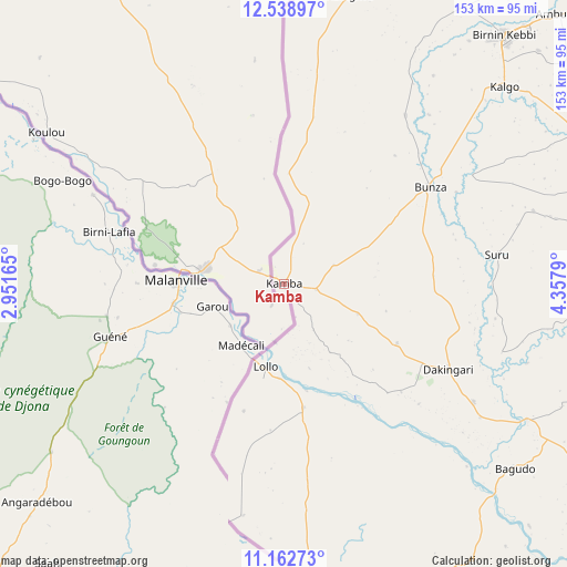
Kamba GPS coordinates[2]
11° 51' 6.192" North, 3° 39' 17.208" East
| Map corner | latitude | longitude |
|---|---|---|
| Upper-left | 12.53897°, | 2.95165° |
| Center: | 11.85172°, | 3.65478° |
| Lower-right: | 11.16273°, | 4.3579° |
| Map W x H: | 153×153 km | = 95.1×95.1mi |
| max Lat: | 13.7543° ⇑17.5% North |
| Kamba: | 11.85172° |
| min Lat: | ⇓82.5% South 4.31231° |
| min Long | Kamba | max Long |
| 2.73333° | 3.65478° | 14.46552° |
| W 5.4%⇐ | ⇒94.6% E |
Elevation
Elevation of Kamba is 177 m = 581 ft, and this is 119.5 m = 392 ft below average elevation for this country.
| Max E: |
1599 m = 5246 ft | 65.1% |
| Avg. | 296.5 m = 973 ft | |
| Kamba | 177 m = 581 ft | |
Min E: |
2 m = 7 ft | 34.9% |
See also: Nigeria elevation on elevation.city.
Geographical zone
Kamba is located in North Torrid zone (between Equator and Tropic of Cancer). Distance of this Northern Tropic circle is 1288.1 km =800.4 mi to North.| Distance of | km | miles | from Kamba |
|---|---|---|---|
| North Pole | 8689.3 | 5399.3 | to North |
| Arctic Circle | 6083.4 | 3780 | to North |
| Tropic Cancer | 1288.1 | 800.4 | to North |
| Equator | 1317.8 | 818.8 | to South |


Nearby cities:
15 places around Kamba: (largest is in red/bold)
• Aliero
101.2 km =62.9 mi,  61°
61°
• Bagudo
79.7 km =49.5 mi,  128°
128°
• Besse
106.7 km =66.3 mi, 127°
• Birnin Kebbi
89.2 km =55.4 mi,  41°
41°
• Bunza
47.2 km =29.3 mi, 56°
• Dakingari
49.8 km =30.9 mi,  117°
117°
• Gulma
116.3 km =72.3 mi, 40°
• Jega
89 km =55.3 mi, 62°
• Kalgo
79.4 km =49.3 mi,  48°
48°
• Kangiwa
80 km =49.7 mi,  12°
12°
• Kebbe
121.4 km =75.4 mi,  75°
75°
• Kende
75.6 km =47 mi, 119°
• Konkwesso
121.7 km =75.6 mi,  156°
156°
• Maiyama
81.8 km =50.8 mi,  71°
71°
• Shanga
123.2 km =76.6 mi, 125°
Sources, notices
• [Note1] Compared only with cities in Nigeria existing in our database
• [Src1] Map data: © OpenStreetMap contributors (CC-BY-SA)
• [Src2] Other city data from geonames.org with taken over terms of usage.
• [Src3] Geographical zone / Annual Mean Temperature by Robert A. Rohde @ Wikipedia
