Imeko geodata
Imeko (Ogun) is a seat of a second-order administrative division; located in Nigeria in Africa/Lagos (GMT+1) time zone. With population of 8,627 people, there are 364 cities with bigger population in this country. Compared to other cities in Nigeria, 63% of cities are located further ↑North; 99.8% of cities are located further →East and 60.6% of cities have higher elevation than Imeko. Note1


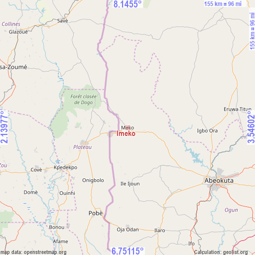
Imeko GPS coordinates[2]
7° 26' 55.968" North, 2° 50' 34.404" East
| Map corner | latitude | longitude |
|---|---|---|
| Upper-left | 8.1455°, | 2.13977° |
| Center: | 7.44888°, | 2.84289° |
| Lower-right: | 6.75115°, | 3.54602° |
| Map W x H: | 155×155 km | = 96.3×96.3mi |
| max Lat: | 13.7543° ⇑63% North |
| Imeko: | 7.44888° |
| min Lat: | ⇓37% South 4.31231° |
| min Long | Imeko | max Long |
| 2.73333° | 2.84289° | 14.46552° |
| W 0.2%⇐ | ⇒99.8% E |
Elevation
Elevation of Imeko is 204 m = 669 ft, and this is 92.5 m = 303 ft below average elevation for this country.
| Max E: |
1599 m = 5246 ft | 60.6% |
| Avg. | 296.5 m = 973 ft | |
| Imeko | 204 m = 669 ft | |
Min E: |
2 m = 7 ft | 39.4% |
See also: Nigeria elevation on elevation.city.
Geographical zone
Imeko is located in North Torrid zone (between Equator and Tropic of Cancer). Distance of Equator is 828.2 km =514.6 mi to South.| Distance of | km | miles | from Imeko |
|---|---|---|---|
| North Pole | 9178.8 | 5703.4 | to North |
| Arctic Circle | 6572.9 | 4084.2 | to North |
| Tropic Cancer | 1777.7 | 1104.6 | to North |
| Equator | 828.2 | 514.6 | to South |


Nearby cities:
15 places around Imeko: (largest is in red/bold)
• Abeokuta
64.3 km =40 mi,  120°
120°
• Ayete
43.1 km =26.8 mi,  75°
75°
• Ayetoro
30.6 km =19 mi,  138°
138°
• Eruwa
64.1 km =39.8 mi, 81°
• Idi Iroko
91.5 km =56.9 mi,  187°
187°
• Ifo
80.5 km =50 mi,  151°
151°
• Igbo-Ora
49.1 km =30.5 mi,  91°
91°
• Ilaro
65.1 km =40.5 mi,  163°
163°
• Itori
71.1 km =44.2 mi, 144°
• Iwere-Ile
66.9 km =41.6 mi,  23°
23°
• Odeda
79.3 km =49.3 mi,  107°
107°
• Okeho
85.6 km =53.2 mi,  40°
40°
• Orita Eruwa
66.1 km =41.1 mi, 80°
• Ota
94.8 km =58.9 mi, 153°
• Owode
91.9 km =57.1 mi,  127°
127°
Sources, notices
• [Note1] Compared only with cities in Nigeria existing in our database
• [Src1] Map data: © OpenStreetMap contributors (CC-BY-SA)
• [Src2] Other city data from geonames.org with taken over terms of usage.
• [Src3] Geographical zone / Annual Mean Temperature by Robert A. Rohde @ Wikipedia
