Igbo-Ora geodata
Igbo-Ora (Oyo) is a seat of a second-order administrative division; located in Nigeria in Africa/Lagos (GMT+1) time zone. With population of 92,719 people, there are 94 cities with bigger population in this country. Compared to other cities in Nigeria, 63.2% of cities are located further ↑North; 98.1% of cities are located further →East and 66.2% of cities have higher elevation than Igbo-Ora. Note1


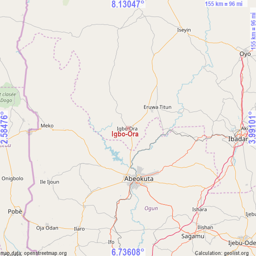
Igbo-Ora GPS coordinates[2]
7° 26' 1.788" North, 3° 17' 16.368" East
| Map corner | latitude | longitude |
|---|---|---|
| Upper-left | 8.13047°, | 2.58476° |
| Center: | 7.43383°, | 3.28788° |
| Lower-right: | 6.73608°, | 3.99101° |
| Map W x H: | 155×155 km | = 96.3×96.3mi |
| max Lat: | 13.7543° ⇑63.2% North |
| Igbo-Ora: | 7.43383° |
| min Lat: | ⇓36.8% South 4.31231° |
| min Long | Igbo-Ora | max Long |
| 2.73333° | 3.28788° | 14.46552° |
| W 1.9%⇐ | ⇒98.1% E |
Elevation
Elevation of Igbo-Ora is 170 m = 558 ft, and this is 126.5 m = 415 ft below average elevation for this country.
| Max E: |
1599 m = 5246 ft | 66.2% |
| Avg. | 296.5 m = 973 ft | |
| Igbo-Ora | 170 m = 558 ft | |
Min E: |
2 m = 7 ft | 33.8% |
See also: Igbo-Ora elevation on elevation.city.
Geographical zone
Igbo-Ora is located in North Torrid zone (between Equator and Tropic of Cancer). Distance of Equator is 826.6 km =513.6 mi to South.| Distance of | km | miles | from Igbo-Ora |
|---|---|---|---|
| North Pole | 9180.5 | 5704.5 | to North |
| Arctic Circle | 6574.6 | 4085.3 | to North |
| Tropic Cancer | 1779.4 | 1105.7 | to North |
| Equator | 826.6 | 513.6 | to South |


Nearby cities:
15 places around Igbo-Ora: (largest is in red/bold)
• Abeokuta
31.6 km =19.6 mi,  168°
168°
• Ayete
14.1 km =8.8 mi,  329°
329°
• Ayetoro
35.8 km =22.2 mi,  233°
233°
• Eruwa
18.1 km =11.2 mi,  52°
52°
• Idi-Ayunre
67.1 km =41.7 mi,  109°
109°
• Ido
51.9 km =32.2 mi,  85°
85°
• Ilaro
67.7 km =42.1 mi,  206°
206°
• Imeko
49.1 km =30.5 mi,  271°
271°
• Isara
65.4 km =40.6 mi,  138°
138°
• Itori
56.4 km =35 mi,  187°
187°
• Iwere-Ile
66.6 km =41.4 mi,  340°
340°
• Odeda
34.7 km =21.6 mi,  130°
130°
• Okeho
67 km =41.6 mi,  5°
5°
• Orita Eruwa
20.6 km =12.8 mi, 51°
• Owode
59.1 km =36.7 mi,  156°
156°
Sources, notices
• [Note1] Compared only with cities in Nigeria existing in our database
• [Src1] Map data: © OpenStreetMap contributors (CC-BY-SA)
• [Src2] Other city data from geonames.org with taken over terms of usage.
• [Src3] Geographical zone / Annual Mean Temperature by Robert A. Rohde @ Wikipedia
