Inndyr geodata
Inndyr (Nordland) is a seat of a second-order administrative division; located in Norway in Europe/Oslo (GMT+2) time zone. With population of 666 people, there are 391 cities with bigger population in this country. Compared to other cities in Norway, 86.9% of cities are located further ↓South; 87.7% of cities are located further ←West and 72.2% of cities have higher elevation than Inndyr. Note1


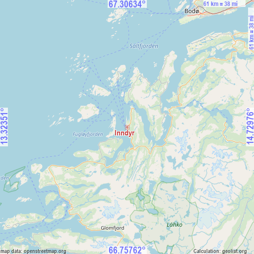
Inndyr GPS coordinates[2]
67° 2' 0.708" North, 14° 1' 35.868" East
| Map corner | latitude | longitude |
|---|---|---|
| Upper-left | 67.30634°, | 13.32351° |
| Center: | 67.03353°, | 14.02663° |
| Lower-right: | 66.75762°, | 14.72976° |
| Map W x H: | 61×61 km | = 37.9×37.9mi |
| max Lat: | 71.04137° ⇑13.1% North |
| Inndyr: | 67.03353° |
| min Lat: | ⇓86.9% South 58.0274° |
| min Long | Inndyr | max Long |
| 4.71485° | 14.02663° | 31.11066° |
| W 87.7%⇐ | ⇒12.3% E |
Elevation
Elevation of Inndyr is 16 m = 52 ft, and this is 88.2 m = 289 ft below average elevation for this country.
| Max E: |
897 m = 2943 ft | 72.2% |
| Avg. | 104.2 m = 342 ft | |
| Inndyr | 16 m = 52 ft | |
Min E: |
1 m = 3 ft | 27.8% |
See also: Norway elevation on elevation.city.
Geographical zone
Inndyr is located in North Frigid zone (between North Pole and Arctic Circle). Distance of this North polar circle is 52.3 km =32.5 mi to South.| Distance of | km | miles | from Inndyr |
|---|---|---|---|
| North Pole | 2553.6 | 1586.7 | to North |
| Arctic Circle | 52.3 | 32.5 | to South |
| Tropic Cancer | 4847.5 | 3012.1 | to South |
| Equator | 7453.4 | 4631.3 | to South |


Nearby cities:
15 places around Inndyr: (largest is in red/bold)
• Bodø
31.9 km =19.8 mi,  30°
30°
• Fauske
64.1 km =39.8 mi,  66°
66°
• Glomfjord
24.4 km =15.2 mi,  188°
188°
• Hauknes
83.4 km =51.8 mi,  178°
178°
• Lurøy
85.9 km =53.4 mi,  217°
217°
• Løding
42.7 km =26.5 mi,  45°
45°
• Løpsmarka
36.1 km =22.4 mi, 30°
• Mo i Rana
80.3 km =49.9 mi, 176°
• Moldjord
24 km =14.9 mi,  97°
97°
• Rognan
59.6 km =37 mi,  82°
82°
• Storforshei
73.3 km =45.5 mi,  162°
162°
• Straumen
76.5 km =47.5 mi,  62°
62°
• Sørland
90.4 km =56.2 mi,  321°
321°
• Vågaholmen
48 km =29.8 mi, 222°
• Ørnes
23 km =14.3 mi, 217°
Sources, notices
• [Note1] Compared only with cities in Norway existing in our database
• [Src1] Map data: © OpenStreetMap contributors (CC-BY-SA)
• [Src2] Other city data from geonames.org with taken over terms of usage.
• [Src3] Geographical zone / Annual Mean Temperature by Robert A. Rohde @ Wikipedia
