Fossbergom geodata
Fossbergom (Oppland) is a seat of a second-order administrative division; located in Norway in Europe/Oslo (GMT+2) time zone. With population of 2,406 people, there are 164 cities with bigger population in this country. Compared to other cities in Norway, 62.5% of cities are located further ↓South; 63% of cities are located further →East and 95.3% of cities have lower elevation than Fossbergom. Note1


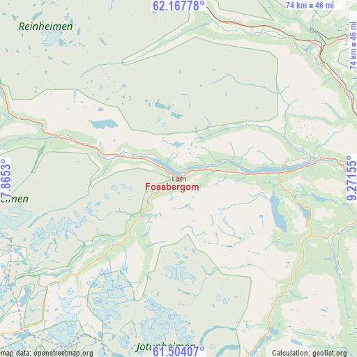
Fossbergom GPS coordinates[2]
61° 50' 15.792" North, 8° 34' 6.312" East
| Map corner | latitude | longitude |
|---|---|---|
| Upper-left | 62.16778°, | 7.8653° |
| Center: | 61.83772°, | 8.56842° |
| Lower-right: | 61.50407°, | 9.27155° |
| Map W x H: | 73.8×73.8 km | = 45.9×45.9mi |
| max Lat: | 71.04137° ⇑37.5% North |
| Fossbergom: | 61.83772° |
| min Lat: | ⇓62.5% South 58.0274° |
| min Long | Fossbergom | max Long |
| 4.71485° | 8.56842° | 31.11066° |
| W 37%⇐ | ⇒63% E |
Elevation
Elevation of Fossbergom is 440 m = 1444 ft, and this is 335.8 m = 1102 ft above average elevation for this country.
| Max E: |
897 m = 2943 ft | 4.7% |
| Fossbergom | 440 m 1444 ft | |
| Avg. | 104.2 m = 342 ft | |
Min E: |
1 m = 3 ft | 95.3% |
See also: Norway elevation on elevation.city.
Geographical zone
Fossbergom is located in North temperate zone (between Tropic of Cancer and the Arctic Circle). Distance of this North polar circle is 525.5 km =326.5 mi to North.| Distance of | km | miles | from Fossbergom |
|---|---|---|---|
| North Pole | 3131.4 | 1945.8 | to North |
| Arctic Circle | 525.5 | 326.5 | to North |
| Tropic Cancer | 4269.8 | 2653.1 | to South |
| Equator | 6875.7 | 4272.4 | to South |


Nearby cities:
15 places around Fossbergom: (largest is in red/bold)
• Bismo
16.6 km =10.3 mi,  288°
288°
• Bismoen
16.6 km =10.3 mi, 287°
• Dale
49.1 km =30.5 mi,  98°
98°
• Dombås
39.4 km =24.5 mi,  47°
47°
• Dovre
39.6 km =24.6 mi,  65°
65°
• Farnes
71.6 km =44.5 mi,  214°
214°
• Folldal
81.5 km =50.6 mi, 66°
• Hundorp
78.9 km =49 mi,  113°
113°
• Kvam
62 km =38.5 mi, 108°
• Lesja
34.8 km =21.6 mi,  26°
26°
• Otta
51.3 km =31.9 mi, 98°
• Vang
79.2 km =49.2 mi,  179°
179°
• Vinstra
67.9 km =42.2 mi, 113°
• Vågåmo
28 km =17.4 mi,  81°
81°
• Årdalstangen
81.1 km =50.4 mi, 214°
Sources, notices
• [Note1] Compared only with cities in Norway existing in our database
• [Src1] Map data: © OpenStreetMap contributors (CC-BY-SA)
• [Src2] Other city data from geonames.org with taken over terms of usage.
• [Src3] Geographical zone / Annual Mean Temperature by Robert A. Rohde @ Wikipedia
