Vinstra geodata
Vinstra (Oppland) is a seat of a second-order administrative division; located in Norway in Europe/Oslo (GMT+2) time zone. With population of 2,449 people, there are 159 cities with bigger population in this country. Compared to other cities in Norway, 61.1% of cities are located further ↓South; 53.3% of cities are located further →East and 93.7% of cities have lower elevation than Vinstra. Note1


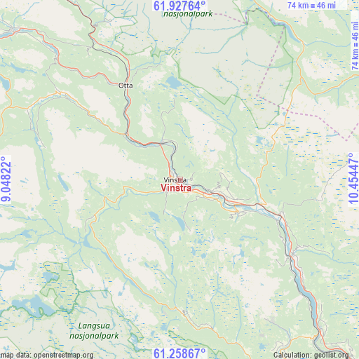
Vinstra GPS coordinates[2]
61° 35' 41.856" North, 9° 45' 4.824" East
| Map corner | latitude | longitude |
|---|---|---|
| Upper-left | 61.92764°, | 9.04822° |
| Center: | 61.59496°, | 9.75134° |
| Lower-right: | 61.25867°, | 10.45447° |
| Map W x H: | 74.4×74.4 km | = 46.2×46.2mi |
| max Lat: | 71.04137° ⇑38.9% North |
| Vinstra: | 61.59496° |
| min Lat: | ⇓61.1% South 58.0274° |
| min Long | Vinstra | max Long |
| 4.71485° | 9.75134° | 31.11066° |
| W 46.7%⇐ | ⇒53.3% E |
Elevation
Elevation of Vinstra is 400 m = 1312 ft, and this is 295.8 m = 970 ft above average elevation for this country.
| Max E: |
897 m = 2943 ft | 6.3% |
| Vinstra | 400 m 1312 ft | |
| Avg. | 104.2 m = 342 ft | |
Min E: |
1 m = 3 ft | 93.7% |
See also: Norway elevation on elevation.city.
Geographical zone
Vinstra is located in North temperate zone (between Tropic of Cancer and the Arctic Circle). Distance of this North polar circle is 552.5 km =343.3 mi to North.| Distance of | km | miles | from Vinstra |
|---|---|---|---|
| North Pole | 3158.3 | 1962.5 | to North |
| Arctic Circle | 552.5 | 343.3 | to North |
| Tropic Cancer | 4242.8 | 2636.4 | to South |
| Equator | 6848.7 | 4255.6 | to South |


Nearby cities:
15 places around Vinstra: (largest is in red/bold)
• Dale
24.2 km =15 mi,  325°
325°
• Dombås
62.7 km =39 mi, 328°
• Dovre
50.8 km =31.6 mi, 329°
• Folldal
61.1 km =38 mi,  12°
12°
• Follebu
50.8 km =31.6 mi,  146°
146°
• Forset
48.4 km =30.1 mi, 154°
• Heggenes
61.9 km =38.5 mi,  215°
215°
• Hundorp
11 km =6.8 mi,  113°
113°
• Kvam
8.5 km =5.3 mi,  336°
336°
• Otta
22.7 km =14.1 mi, 329°
• Ringebu
21.8 km =13.5 mi, 109°
• Segalstad
47.7 km =29.6 mi, 147°
• Segalstad bru
47.9 km =29.8 mi, 148°
• Tretten
42.7 km =26.5 mi,  136°
136°
• Vågåmo
46.5 km =28.9 mi,  312°
312°
Sources, notices
• [Note1] Compared only with cities in Norway existing in our database
• [Src1] Map data: © OpenStreetMap contributors (CC-BY-SA)
• [Src2] Other city data from geonames.org with taken over terms of usage.
• [Src3] Geographical zone / Annual Mean Temperature by Robert A. Rohde @ Wikipedia
