Vågåmo geodata
Vågåmo (Oppland) is a seat of a second-order administrative division; located in Norway in Europe/Oslo (GMT+2) time zone. With population of 1,463 people, there are 244 cities with bigger population in this country. Compared to other cities in Norway, 62.7% of cities are located further ↓South; 59% of cities are located further →East and 93.7% of cities have lower elevation than Vågåmo. Note1


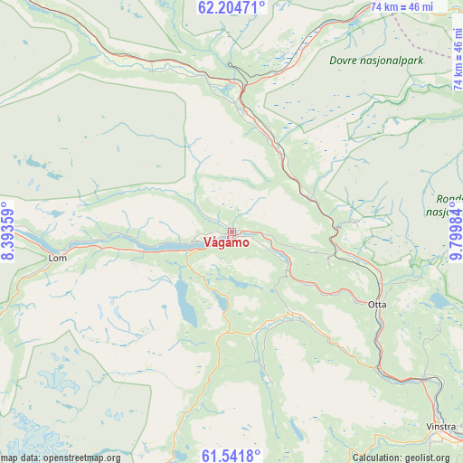
Vågåmo GPS coordinates[2]
61° 52' 30.18" North, 9° 5' 48.156" East
| Map corner | latitude | longitude |
|---|---|---|
| Upper-left | 62.20471°, | 8.39359° |
| Center: | 61.87505°, | 9.09671° |
| Lower-right: | 61.5418°, | 9.79984° |
| Map W x H: | 73.7×73.7 km | = 45.8×45.8mi |
| max Lat: | 71.04137° ⇑37.3% North |
| Vågåmo: | 61.87505° |
| min Lat: | ⇓62.7% South 58.0274° |
| min Long | Vågåmo | max Long |
| 4.71485° | 9.09671° | 31.11066° |
| W 41%⇐ | ⇒59% E |
Elevation
Elevation of Vågåmo is 400 m = 1312 ft, and this is 295.8 m = 970 ft above average elevation for this country.
| Max E: |
897 m = 2943 ft | 6.3% |
| Vågåmo | 400 m 1312 ft | |
| Avg. | 104.2 m = 342 ft | |
Min E: |
1 m = 3 ft | 93.7% |
See also: Norway elevation on elevation.city.
Geographical zone
Vågåmo is located in North temperate zone (between Tropic of Cancer and the Arctic Circle). Distance of this North polar circle is 521.3 km =323.9 mi to North.| Distance of | km | miles | from Vågåmo |
|---|---|---|---|
| North Pole | 3127.2 | 1943.2 | to North |
| Arctic Circle | 521.3 | 323.9 | to North |
| Tropic Cancer | 4273.9 | 2655.7 | to South |
| Equator | 6879.9 | 4275 | to South |


Nearby cities:
15 places around Vågåmo: (largest is in red/bold)
• Alvdal
84.2 km =52.3 mi,  72°
72°
• Bismo
43.5 km =27 mi,  271°
271°
• Bismoen
43.5 km =27 mi, 271°
• Dale
23.6 km =14.7 mi,  117°
117°
• Dombås
22.4 km =13.9 mi,  4°
4°
• Dovre
15 km =9.3 mi,  33°
33°
• Folldal
55 km =34.2 mi,  58°
58°
• Fossbergom
28 km =17.4 mi,  261°
261°
• Heggenes
81.3 km =50.5 mi,  181°
181°
• Hundorp
56.9 km =35.4 mi,  128°
128°
• Kvam
38.9 km =24.2 mi, 126°
• Lesja
29.7 km =18.5 mi,  335°
335°
• Otta
25.8 km =16 mi, 116°
• Ringebu
67 km =41.6 mi, 124°
• Vinstra
46.5 km =28.9 mi, 132°
Sources, notices
• [Note1] Compared only with cities in Norway existing in our database
• [Src1] Map data: © OpenStreetMap contributors (CC-BY-SA)
• [Src2] Other city data from geonames.org with taken over terms of usage.
• [Src3] Geographical zone / Annual Mean Temperature by Robert A. Rohde @ Wikipedia
