San José geodata
San José (Herrera) is a populated place; located in Panama in America/Panama (GMT-5) time zone. With population of 580 people, there are 420 cities with bigger population in this country. Compared to other cities in Panama, 84.1% of cities are located further ↑North; 57.9% of cities are located further →East and 69.6% of cities have lower elevation than San José. Note1


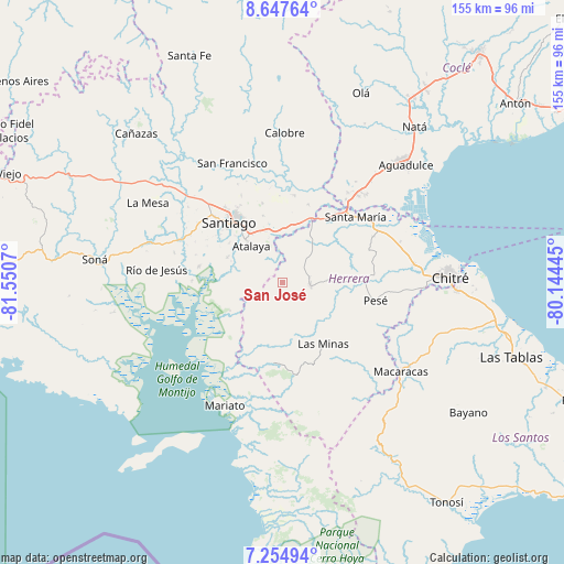
San José GPS coordinates[2]
7° 57' 6.768" North, 80° 50' 51.252" West
| Map corner | latitude | longitude |
|---|---|---|
| Upper-left | 8.64764°, | -81.5507° |
| Center: | 7.95188°, | -80.84757° |
| Lower-right: | 7.25494°, | -80.14445° |
| Map W x H: | 154.9×154.9 km | = 96.3×96.3mi |
| max Lat: | 9.60898° ⇑84.1% North |
| San José: | 7.95188° |
| min Lat: | ⇓15.9% South 7.26534° |
| min Long | San José | max Long |
| -82.91275° | -80.84757° | -77.38965° |
| W 42.1%⇐ | ⇒57.9% E |
Elevation
Elevation of San José is 155 m = 509 ft, and this is 17.1 m = 56 ft below average elevation for this country.
| Max E: |
2103 m = 6900 ft | 30.4% |
| Avg. | 172.1 m = 565 ft | |
| San José | 155 m = 509 ft | |
Min E: |
-1 m = -3 ft | 69.6% |
See also: Panama elevation on elevation.city.
Geographical zone
San José is located in North Torrid zone (between Equator and Tropic of Cancer). Distance of Equator is 884.2 km =549.4 mi to South.| Distance of | km | miles | from San José |
|---|---|---|---|
| North Pole | 9122.9 | 5668.7 | to North |
| Arctic Circle | 6517 | 4049.5 | to North |
| Tropic Cancer | 1721.8 | 1069.9 | to North |
| Equator | 884.2 | 549.4 | to South |


Nearby cities:
15 places around San José: (largest is in red/bold)
• Atalaya
13.2 km =8.2 mi,  319°
319°
• Cabuya
9.8 km =6.1 mi,  69°
69°
• Cerro Largo
13.2 km =8.2 mi,  172°
172°
• Chupampa
15.9 km =9.9 mi,  29°
29°
• El Barrito
11.1 km =6.9 mi,  275°
275°
• El Espino de Santa Rosa
15.9 km =9.9 mi,  9°
9°
• El Limón
14.4 km =8.9 mi, 34°
• La Carrillo
4.4 km =2.7 mi,  296°
296°
• La Mata
15.7 km =9.8 mi,  347°
347°
• La Montañuela
8.3 km =5.2 mi, 347°
• Las Guabas
6.5 km =4 mi,  136°
136°
• Llano Grande
15.2 km =9.4 mi,  80°
80°
• Los Boquerones
14.2 km =8.8 mi,  356°
356°
• Ocú
7.6 km =4.7 mi,  99°
99°
• Peñas Chatas
8.5 km =5.3 mi, 34°
Sources, notices
• [Note1] Compared only with cities in Panama existing in our database
• [Src1] Map data: © OpenStreetMap contributors (CC-BY-SA)
• [Src2] Other city data from geonames.org with taken over terms of usage.
• [Src3] Geographical zone / Annual Mean Temperature by Robert A. Rohde @ Wikipedia
