Tournavista geodata
Tournavista (Huanuco) is a seat of a third-order administrative division; located in Peru in America/Lima (GMT-5) time zone. In our database, there are 305 cities with bigger population. Compared to other cities in Peru, 69.5% of cities are located further ↓South; 60.4% of cities are located further ←West and 84.7% of cities have higher elevation than Tournavista. Note1


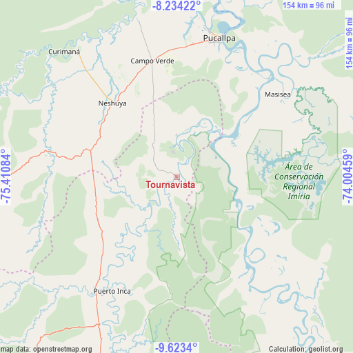
Tournavista GPS coordinates[2]
8° 55' 46.092" South, 74° 42' 27.756" West
| Map corner | latitude | longitude |
|---|---|---|
| Upper-left | -8.23422°, | -75.41084° |
| Center: | -8.92947°, | -74.70771° |
| Lower-right: | -9.6234°, | -74.00459° |
| Map W x H: | 154.5×154.5 km | = 96×96mi |
| max Lat: | -0.96667° ⇑30.5% North |
| Tournavista: | -8.92947° |
| min Lat: | ⇓69.5% South -18.01465° |
| min Long | Tournavista | max Long |
| -81.30472° | -74.70771° | -69.04167° |
| W 60.4%⇐ | ⇒39.6% E |
Elevation
Elevation of Tournavista is 190 m = 623 ft, and this is 2128.7 m = 6984 ft below average elevation for this country.
| Max E: |
5022 m = 16476 ft | 84.7% |
| Avg. | 2318.7 m = 7607 ft | |
| Tournavista | 190 m = 623 ft | |
Min E: |
1 m = 3 ft | 15.3% |
See also: Peru elevation on elevation.city.
Geographical zone
Tournavista is located in South Torrid zone (between Equator and Tropic of Capricorn). Distance of Equator is 992.9 km =617 mi to North.| Distance of | km | miles | from Tournavista |
|---|---|---|---|
| Equator | 992.9 | 617 | to North |
| Tropic Capricorn | 1613.1 | 1002.3 | to South |
| Antarctic Circle | 6408.3 | 3981.9 | to South |
| South Pole | 9014.2 | 5601.2 | to South |


Nearby cities:
15 places around Tournavista: (largest is in red/bold)
• Aucayacu
154.4 km =95.9 mi,  269°
269°
• Bolognesi
147.9 km =91.9 mi,  148°
148°
• Campoverde
51.7 km =32.1 mi,  347°
347°
• Chaglla
165.9 km =103.1 mi,  232°
232°
• Honoria
17.8 km =11.1 mi,  359°
359°
• Iparia
45.4 km =28.2 mi,  155°
155°
• Las Palmas
151.1 km =93.9 mi,  250°
250°
• Masisea
57.1 km =35.5 mi,  50°
50°
• Nueva Requena
70.8 km =44 mi, 346°
• Pozuzo
155.5 km =96.6 mi,  215°
215°
• Pucallpa
63.5 km =39.5 mi,  15°
15°
• Puerto Callao
65.2 km =40.5 mi,  13°
13°
• Puerto Inca
57.3 km =35.6 mi,  209°
209°
• Tingo María
147.1 km =91.4 mi, 253°
• Yuyapichis
83 km =51.6 mi,  200°
200°
Sources, notices
• [Note1] Compared only with cities in Peru existing in our database
• [Src1] Map data: © OpenStreetMap contributors (CC-BY-SA)
• [Src2] Other city data from geonames.org with taken over terms of usage.
• [Src3] Geographical zone / Annual Mean Temperature by Robert A. Rohde @ Wikipedia
