Puerto Inca geodata
Puerto Inca (Huanuco) is a seat of a second-order administrative division; located in Peru in America/Lima (GMT-5) time zone. In our database, there are 305 cities with bigger population. Compared to other cities in Peru, 65.6% of cities are located further ↓South; 59.1% of cities are located further ←West and 84.3% of cities have higher elevation than Puerto Inca. Note1


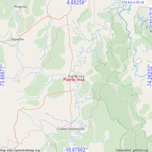
Puerto Inca GPS coordinates[2]
9° 22' 37.2" South, 74° 57' 56.304" West
| Map corner | latitude | longitude |
|---|---|---|
| Upper-left | -8.68259°, | -75.66877° |
| Center: | -9.377°, | -74.96564° |
| Lower-right: | -10.07002°, | -74.26252° |
| Map W x H: | 154.3×154.3 km | = 95.9×95.9mi |
| max Lat: | -0.96667° ⇑34.4% North |
| Puerto Inca: | -9.377° |
| min Lat: | ⇓65.6% South -18.01465° |
| min Long | Puerto Inca | max Long |
| -81.30472° | -74.96564° | -69.04167° |
| W 59.1%⇐ | ⇒40.9% E |
Elevation
Elevation of Puerto Inca is 205 m = 673 ft, and this is 2113.7 m = 6935 ft below average elevation for this country.
| Max E: |
5022 m = 16476 ft | 84.3% |
| Avg. | 2318.7 m = 7607 ft | |
| Puerto Inca | 205 m = 673 ft | |
Min E: |
1 m = 3 ft | 15.7% |
See also: Peru elevation on elevation.city.
Geographical zone
Puerto Inca is located in South Torrid zone (between Equator and Tropic of Capricorn). Distance of Equator is 1042.6 km =647.8 mi to North.| Distance of | km | miles | from Puerto Inca |
|---|---|---|---|
| Equator | 1042.6 | 647.8 | to North |
| Tropic Capricorn | 1563.3 | 971.4 | to South |
| Antarctic Circle | 6358.5 | 3951 | to South |
| South Pole | 8964.4 | 5570.2 | to South |


Nearby cities:
15 places around Puerto Inca: (largest is in red/bold)
• Campoverde
101.8 km =63.3 mi,  9°
9°
• Chaglla
115.1 km =71.5 mi,  243°
243°
• Honoria
73.2 km =45.5 mi,  22°
22°
• Huancabamba
124.8 km =77.5 mi,  209°
209°
• Iparia
48.2 km =30 mi,  79°
79°
• Las Palmas
114 km =70.8 mi,  269°
269°
• Masisea
112.4 km =69.8 mi,  40°
40°
• Nueva Requena
119 km =73.9 mi, 5°
• Panao
126.7 km =78.7 mi, 242°
• Pozuzo
98.7 km =61.3 mi,  219°
219°
• Pucallpa
119.8 km =74.4 mi, 22°
• Puerto Callao
121.2 km =75.3 mi, 20°
• Tingo María
113.4 km =70.5 mi, 274°
• Tournavista
57.3 km =35.6 mi,  29°
29°
• Yuyapichis
27.9 km =17.3 mi,  182°
182°
Sources, notices
• [Note1] Compared only with cities in Peru existing in our database
• [Src1] Map data: © OpenStreetMap contributors (CC-BY-SA)
• [Src2] Other city data from geonames.org with taken over terms of usage.
• [Src3] Geographical zone / Annual Mean Temperature by Robert A. Rohde @ Wikipedia
