Yazman geodata
Yazman (Punjab) is a populated place; located in Pakistan in Asia/Karachi (GMT+5) time zone. With population of 24,580 people, there are 243 cities with bigger population in this country. Compared to other cities in Pakistan, 65.9% of cities are located further ↑North; 53.3% of cities are located further ←West and 66.6% of cities have higher elevation than Yazman. Note1


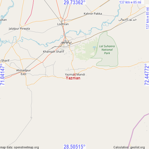
Yazman GPS coordinates[2]
29° 7' 16.392" North, 71° 44' 40.524" East
| Map corner | latitude | longitude |
|---|---|---|
| Upper-left | 29.73362°, | 71.04147° |
| Center: | 29.12122°, | 71.74459° |
| Lower-right: | 28.50515°, | 72.44772° |
| Map W x H: | 136.6×136.6 km | = 84.9×84.9mi |
| max Lat: | 36.32162° ⇑65.9% North |
| Yazman: | 29.12122° |
| min Lat: | ⇓34.1% South 24.14422° |
| min Long | Yazman | max Long |
| 61.74573° | 71.74459° | 75.63372° |
| W 53.3%⇐ | ⇒46.7% E |
Elevation
Elevation of Yazman is 120 m = 394 ft, and this is 225 m = 738 ft below average elevation for this country.
| Max E: |
2732 m = 8963 ft | 66.6% |
| Avg. | 345 m = 1132 ft | |
| Yazman | 120 m = 394 ft | |
Min E: |
3 m = 10 ft | 33.4% |
See also: Pakistan elevation on elevation.city.
Geographical zone
Yazman is located in North temperate zone (between Tropic of Cancer and the Arctic Circle). Distance of this Northern Tropic circle is 632.1 km =392.8 mi to South.| Distance of | km | miles | from Yazman |
|---|---|---|---|
| North Pole | 6769.1 | 4206.1 | to North |
| Arctic Circle | 4163.2 | 2586.9 | to North |
| Tropic Cancer | 632.1 | 392.8 | to South |
| Equator | 3238 | 2012 | to South |


Nearby cities:
15 places around Yazman: (largest is in red/bold)
• Ahmadpur East
47.3 km =29.4 mi,  272°
272°
• Alipur
85.9 km =53.4 mi,  289°
289°
• Bahawalpur
31.5 km =19.6 mi,  347°
347°
• Dhanot
51 km =31.7 mi,  0°
0°
• Dunyapur
75.8 km =47.1 mi,  359°
359°
• Hasilpur
100.3 km =62.3 mi,  50°
50°
• Jalalpur Pirwala
66.2 km =41.1 mi,  310°
310°
• Jatoi Shimali
97.8 km =60.8 mi,  296°
296°
• Kahror Pakka
58.3 km =36.2 mi,  16°
16°
• Khairpur Tamewah
70 km =43.5 mi,  43°
43°
• Khangarh
104.7 km =65.1 mi,  327°
327°
• Lodhran
47.2 km =29.3 mi, 346°
• Mailsi
86.3 km =53.6 mi,  28°
28°
• Shahr Sultan
86.3 km =53.6 mi, 305°
• Shujaabad
95.1 km =59.1 mi, 332°
Sources, notices
• [Note1] Compared only with cities in Pakistan existing in our database
• [Src1] Map data: © OpenStreetMap contributors (CC-BY-SA)
• [Src2] Other city data from geonames.org with taken over terms of usage.
• [Src3] Geographical zone / Annual Mean Temperature by Robert A. Rohde @ Wikipedia
