Jatoi Shimali geodata
Jatoi Shimali (Punjab) is a populated place; located in Pakistan in Asia/Karachi (GMT+5) time zone. With population of 47,144 people, there are 136 cities with bigger population in this country. Compared to other cities in Pakistan, 64.1% of cities are located further ↑North; 57.8% of cities are located further →East and 67.9% of cities have higher elevation than Jatoi Shimali. Note1


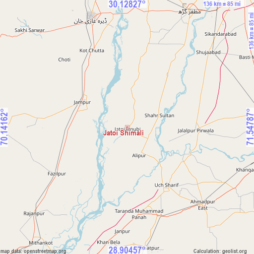
Jatoi Shimali GPS coordinates[2]
29° 31' 5.772" North, 70° 50' 41.064" East
| Map corner | latitude | longitude |
|---|---|---|
| Upper-left | 30.12827°, | 70.14162° |
| Center: | 29.51827°, | 70.84474° |
| Lower-right: | 28.90457°, | 71.54787° |
| Map W x H: | 136.1×136.1 km | = 84.6×84.6mi |
| max Lat: | 36.32162° ⇑64.1% North |
| Jatoi Shimali: | 29.51827° |
| min Lat: | ⇓35.9% South 24.14422° |
| min Long | Jatoi Shimali | max Long |
| 61.74573° | 70.84474° | 75.63372° |
| W 42.2%⇐ | ⇒57.8% E |
Elevation
Elevation of Jatoi Shimali is 106 m = 348 ft, and this is 239 m = 784 ft below average elevation for this country.
| Max E: |
2732 m = 8963 ft | 67.9% |
| Avg. | 345 m = 1132 ft | |
| Jatoi Shimali | 106 m = 348 ft | |
Min E: |
3 m = 10 ft | 32.1% |
See also: Jatoi Shimali elevation on elevation.city.
Geographical zone
Jatoi Shimali is located in North temperate zone (between Tropic of Cancer and the Arctic Circle). Distance of this Northern Tropic circle is 676.2 km =420.2 mi to South.| Distance of | km | miles | from Jatoi Shimali |
|---|---|---|---|
| North Pole | 6724.9 | 4178.7 | to North |
| Arctic Circle | 4119.1 | 2559.5 | to North |
| Tropic Cancer | 676.2 | 420.2 | to South |
| Equator | 3282.1 | 2039.4 | to South |


Nearby cities:
15 places around Jatoi Shimali: (largest is in red/bold)
• Ahmadpur East
57.8 km =35.9 mi,  136°
136°
• Alipur
16.4 km =10.2 mi,  156°
156°
• Bahawalpur
81.5 km =50.6 mi,  99°
99°
• Dajal
45.5 km =28.3 mi,  275°
275°
• Dera Ghazi Khan
61.9 km =38.5 mi,  341°
341°
• Dhanot
88 km =54.7 mi,  85°
85°
• Jalalpur Pirwala
36.5 km =22.7 mi, 92°
• Jampur
27.8 km =17.3 mi,  299°
299°
• Khangarh
53.6 km =33.3 mi,  34°
34°
• Lodhran
76.2 km =47.3 mi, 88°
• Muzaffargarh
70.2 km =43.6 mi, 28°
• Rajanpur
67.9 km =42.2 mi,  227°
227°
• Shahr Sultan
18.3 km =11.4 mi,  69°
69°
• Shujaabad
59.2 km =36.8 mi,  47°
47°
• Zahir Pir
84.4 km =52.4 mi,  201°
201°
Sources, notices
• [Note1] Compared only with cities in Pakistan existing in our database
• [Src1] Map data: © OpenStreetMap contributors (CC-BY-SA)
• [Src2] Other city data from geonames.org with taken over terms of usage.
• [Src3] Geographical zone / Annual Mean Temperature by Robert A. Rohde @ Wikipedia
