Lodhran geodata
Lodhran (Punjab) is a seat of a second-order administrative division; located in Pakistan in Asia/Karachi (GMT+5) time zone. With population of 97,249 people, there are 68 cities with bigger population in this country. Compared to other cities in Pakistan, 63.9% of cities are located further ↑North; 51.7% of cities are located further ←West and 66.8% of cities have higher elevation than Lodhran. Note1


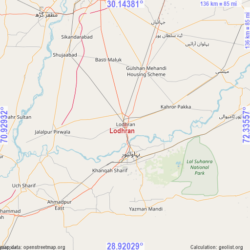
Lodhran GPS coordinates[2]
29° 32' 2.04" North, 71° 37' 56.784" East
| Map corner | latitude | longitude |
|---|---|---|
| Upper-left | 30.14381°, | 70.92932° |
| Center: | 29.5339°, | 71.63244° |
| Lower-right: | 28.92029°, | 72.33557° |
| Map W x H: | 136×136 km | = 84.5×84.5mi |
| max Lat: | 36.32162° ⇑63.9% North |
| Lodhran: | 29.5339° |
| min Lat: | ⇓36.1% South 24.14422° |
| min Long | Lodhran | max Long |
| 61.74573° | 71.63244° | 75.63372° |
| W 51.7%⇐ | ⇒48.3% E |
Elevation
Elevation of Lodhran is 116 m = 381 ft, and this is 229 m = 751 ft below average elevation for this country.
| Max E: |
2732 m = 8963 ft | 66.8% |
| Avg. | 345 m = 1132 ft | |
| Lodhran | 116 m = 381 ft | |
Min E: |
3 m = 10 ft | 33.2% |
See also: Lodhran elevation on elevation.city.
Geographical zone
Lodhran is located in North temperate zone (between Tropic of Cancer and the Arctic Circle). Distance of this Northern Tropic circle is 677.9 km =421.2 mi to South.| Distance of | km | miles | from Lodhran |
|---|---|---|---|
| North Pole | 6723.2 | 4177.6 | to North |
| Arctic Circle | 4117.3 | 2558.4 | to North |
| Tropic Cancer | 677.9 | 421.2 | to South |
| Equator | 3283.9 | 2040.5 | to South |


Nearby cities:
15 places around Lodhran: (largest is in red/bold)
• Ahmadpur East
56.7 km =35.2 mi,  219°
219°
• Alipur
71.8 km =44.6 mi,  256°
256°
• Bahawalpur
15.7 km =9.8 mi,  164°
164°
• Dhanot
12.7 km =7.9 mi,  66°
66°
• Dunyapur
31.8 km =19.8 mi,  19°
19°
• Jalalpur Pirwala
39.8 km =24.7 mi,  265°
265°
• Kahror Pakka
29.1 km =18.1 mi, 69°
• Khairpur Tamewah
58.8 km =36.5 mi,  84°
84°
• Khangarh
62.2 km =38.6 mi,  312°
312°
• Mailsi
60.2 km =37.4 mi,  60°
60°
• Multan
75.2 km =46.7 mi,  348°
348°
• Muzaffargarh
73.3 km =45.5 mi,  324°
324°
• Shahr Sultan
59.2 km =36.8 mi, 274°
• Shujaabad
50.6 km =31.4 mi, 319°
• Yazman
47.2 km =29.3 mi,  166°
166°
Sources, notices
• [Note1] Compared only with cities in Pakistan existing in our database
• [Src1] Map data: © OpenStreetMap contributors (CC-BY-SA)
• [Src2] Other city data from geonames.org with taken over terms of usage.
• [Src3] Geographical zone / Annual Mean Temperature by Robert A. Rohde @ Wikipedia
