Shahr Sultan geodata
Shahr Sultan (Punjab) is a populated place; located in Pakistan in Asia/Karachi (GMT+5) time zone. With population of 16,166 people, there are 301 cities with bigger population in this country. Compared to other cities in Pakistan, 63% of cities are located further ↑North; 54.4% of cities are located further →East and 67% of cities have higher elevation than Shahr Sultan. Note1


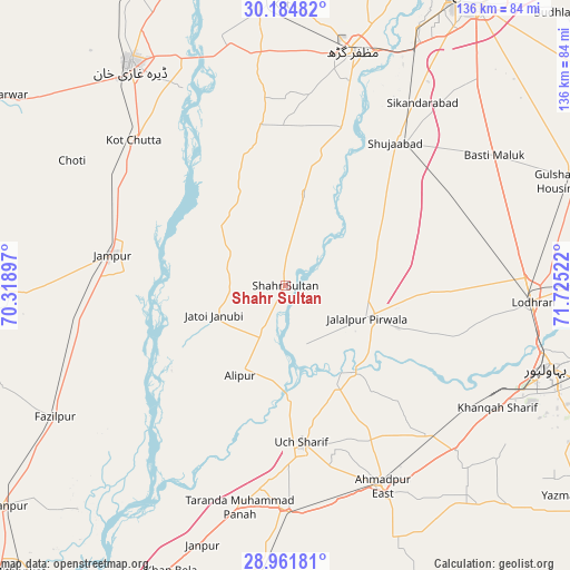
Shahr Sultan GPS coordinates[2]
29° 34' 30.612" North, 71° 1' 19.524" East
| Map corner | latitude | longitude |
|---|---|---|
| Upper-left | 30.18482°, | 70.31897° |
| Center: | 29.57517°, | 71.02209° |
| Lower-right: | 28.96181°, | 71.72522° |
| Map W x H: | 136×136 km | = 84.5×84.5mi |
| max Lat: | 36.32162° ⇑63% North |
| Shahr Sultan: | 29.57517° |
| min Lat: | ⇓37% South 24.14422° |
| min Long | Shahr Sultan | max Long |
| 61.74573° | 71.02209° | 75.63372° |
| W 45.6%⇐ | ⇒54.4% E |
Elevation
Elevation of Shahr Sultan is 111 m = 364 ft, and this is 234 m = 768 ft below average elevation for this country.
| Max E: |
2732 m = 8963 ft | 67% |
| Avg. | 345 m = 1132 ft | |
| Shahr Sultan | 111 m = 364 ft | |
Min E: |
3 m = 10 ft | 33% |
See also: Pakistan elevation on elevation.city.
Geographical zone
Shahr Sultan is located in North temperate zone (between Tropic of Cancer and the Arctic Circle). Distance of this Northern Tropic circle is 682.5 km =424.1 mi to South.| Distance of | km | miles | from Shahr Sultan |
|---|---|---|---|
| North Pole | 6718.6 | 4174.7 | to North |
| Arctic Circle | 4112.7 | 2555.5 | to North |
| Tropic Cancer | 682.5 | 424.1 | to South |
| Equator | 3288.5 | 2043.4 | to South |


Nearby cities:
15 places around Shahr Sultan: (largest is in red/bold)
• Ahmadpur East
53.2 km =33.1 mi,  154°
154°
• Alipur
24 km =14.9 mi,  206°
206°
• Bahawalpur
66.2 km =41.1 mi,  107°
107°
• Dajal
62.5 km =38.8 mi,  268°
268°
• Dera Ghazi Khan
64 km =39.8 mi,  324°
324°
• Dhanot
70.6 km =43.9 mi,  89°
89°
• Dunyapur
74.1 km =46 mi,  70°
70°
• Jalalpur Pirwala
20.9 km =13 mi, 111°
• Jampur
41.9 km =26 mi,  280°
280°
• Jatoi Shimali
18.3 km =11.4 mi,  249°
249°
• Khangarh
40 km =24.9 mi,  19°
19°
• Lodhran
59.2 km =36.8 mi, 94°
• Multan
81.9 km =50.9 mi,  32°
32°
• Muzaffargarh
57.7 km =35.9 mi, 16°
• Shujaabad
42.9 km =26.7 mi,  37°
37°
Sources, notices
• [Note1] Compared only with cities in Pakistan existing in our database
• [Src1] Map data: © OpenStreetMap contributors (CC-BY-SA)
• [Src2] Other city data from geonames.org with taken over terms of usage.
• [Src3] Geographical zone / Annual Mean Temperature by Robert A. Rohde @ Wikipedia
