Alipur geodata
Alipur (Punjab) is a populated place; located in Pakistan in Asia/Karachi (GMT+5) time zone. With population of 33,601 people, there are 189 cities with bigger population in this country. Compared to other cities in Pakistan, 65.2% of cities are located further ↑North; 56.2% of cities are located further →East and 67.7% of cities have higher elevation than Alipur. Note1


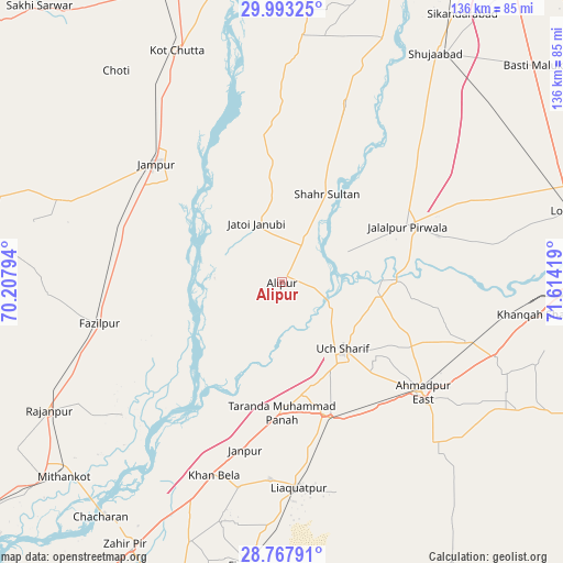
Alipur GPS coordinates[2]
29° 22' 56.712" North, 70° 54' 39.816" East
| Map corner | latitude | longitude |
|---|---|---|
| Upper-left | 29.99325°, | 70.20794° |
| Center: | 29.38242°, | 70.91106° |
| Lower-right: | 28.76791°, | 71.61419° |
| Map W x H: | 136.2×136.2 km | = 84.6×84.6mi |
| max Lat: | 36.32162° ⇑65.2% North |
| Alipur: | 29.38242° |
| min Lat: | ⇓34.8% South 24.14422° |
| min Long | Alipur | max Long |
| 61.74573° | 70.91106° | 75.63372° |
| W 43.8%⇐ | ⇒56.2% E |
Elevation
Elevation of Alipur is 107 m = 351 ft, and this is 238 m = 781 ft below average elevation for this country.
| Max E: |
2732 m = 8963 ft | 67.7% |
| Avg. | 345 m = 1132 ft | |
| Alipur | 107 m = 351 ft | |
Min E: |
3 m = 10 ft | 32.3% |
See also: Pakistan elevation on elevation.city.
Geographical zone
Alipur is located in North temperate zone (between Tropic of Cancer and the Arctic Circle). Distance of this Northern Tropic circle is 661.1 km =410.8 mi to South.| Distance of | km | miles | from Alipur |
|---|---|---|---|
| North Pole | 6740 | 4188 | to North |
| Arctic Circle | 4134.2 | 2568.9 | to North |
| Tropic Cancer | 661.1 | 410.8 | to South |
| Equator | 3267 | 2030 | to South |


Nearby cities:
15 places around Alipur: (largest is in red/bold)
• Ahmadpur East
42.9 km =26.7 mi,  128°
128°
• Bahawalpur
74 km =46 mi,  88°
88°
• Dajal
55.3 km =34.4 mi,  290°
290°
• Dera Ghazi Khan
78.3 km =48.7 mi,  340°
340°
• Dhanot
84.3 km =52.4 mi,  74°
74°
• Jalalpur Pirwala
33.1 km =20.6 mi, 65°
• Jampur
42.1 km =26.2 mi,  313°
313°
• Jatoi Shimali
16.4 km =10.2 mi, 336°
• Khangarh
63.9 km =39.7 mi,  22°
22°
• Lodhran
71.8 km =44.6 mi,  76°
76°
• Muzaffargarh
81.4 km =50.6 mi, 19°
• Rajanpur
64.3 km =40 mi,  241°
241°
• Shahr Sultan
24 km =14.9 mi,  26°
26°
• Shujaabad
66.6 km =41.4 mi, 33°
• Zahir Pir
73.7 km =45.8 mi,  210°
210°
Sources, notices
• [Note1] Compared only with cities in Pakistan existing in our database
• [Src1] Map data: © OpenStreetMap contributors (CC-BY-SA)
• [Src2] Other city data from geonames.org with taken over terms of usage.
• [Src3] Geographical zone / Annual Mean Temperature by Robert A. Rohde @ Wikipedia
