Shujaabad geodata
Shujaabad (Punjab) is a populated place; located in Pakistan in Asia/Karachi (GMT+5) time zone. With population of 65,952 people, there are 107 cities with bigger population in this country. Compared to other cities in Pakistan, 59.8% of cities are located further ↑North; 51.5% of cities are located further →East and 65% of cities have higher elevation than Shujaabad. Note1


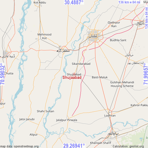
Shujaabad GPS coordinates[2]
29° 52' 51.312" North, 71° 17' 36.384" East
| Map corner | latitude | longitude |
|---|---|---|
| Upper-left | 30.4887°, | 70.59032° |
| Center: | 29.88092°, | 71.29344° |
| Lower-right: | 29.26941°, | 71.99657° |
| Map W x H: | 135.6×135.6 km | = 84.3×84.3mi |
| max Lat: | 36.32162° ⇑59.8% North |
| Shujaabad: | 29.88092° |
| min Lat: | ⇓40.2% South 24.14422° |
| min Long | Shujaabad | max Long |
| 61.74573° | 71.29344° | 75.63372° |
| W 48.5%⇐ | ⇒51.5% E |
Elevation
Elevation of Shujaabad is 123 m = 404 ft, and this is 222 m = 728 ft below average elevation for this country.
| Max E: |
2732 m = 8963 ft | 65% |
| Avg. | 345 m = 1132 ft | |
| Shujaabad | 123 m = 404 ft | |
Min E: |
3 m = 10 ft | 35% |
See also: Shujaabad elevation on elevation.city.
Geographical zone
Shujaabad is located in North temperate zone (between Tropic of Cancer and the Arctic Circle). Distance of this Northern Tropic circle is 716.5 km =445.2 mi to South.| Distance of | km | miles | from Shujaabad |
|---|---|---|---|
| North Pole | 6684.6 | 4153.6 | to North |
| Arctic Circle | 4078.7 | 2534.4 | to North |
| Tropic Cancer | 716.5 | 445.2 | to South |
| Equator | 3322.4 | 2064.4 | to South |


Nearby cities:
15 places around Shujaabad: (largest is in red/bold)
• Alipur
66.6 km =41.4 mi,  213°
213°
• Bahawalpur
65.2 km =40.5 mi,  145°
145°
• Dera Ghazi Khan
65.5 km =40.7 mi,  286°
286°
• Dhanot
55.5 km =34.5 mi,  127°
127°
• Dunyapur
44.3 km =27.5 mi,  101°
101°
• Jalalpur Pirwala
42.4 km =26.3 mi,  189°
189°
• Jampur
72.4 km =45 mi,  248°
248°
• Jatoi Shimali
59.2 km =36.8 mi,  227°
227°
• Kahror Pakka
66.4 km =41.3 mi,  115°
115°
• Khangarh
13.3 km =8.3 mi, 286°
• Lodhran
50.6 km =31.4 mi,  139°
139°
• Multan
39.4 km =24.5 mi,  26°
26°
• Muzaffargarh
23.4 km =14.5 mi,  335°
335°
• Qadirpur Ran
58.4 km =36.3 mi,  38°
38°
• Shahr Sultan
42.9 km =26.7 mi,  217°
217°
Sources, notices
• [Note1] Compared only with cities in Pakistan existing in our database
• [Src1] Map data: © OpenStreetMap contributors (CC-BY-SA)
• [Src2] Other city data from geonames.org with taken over terms of usage.
• [Src3] Geographical zone / Annual Mean Temperature by Robert A. Rohde @ Wikipedia
