Dhanot geodata
Dhanot (Punjab) is a populated place; located in Pakistan in Asia/Karachi (GMT+5) time zone. With population of 18,729 people, there are 278 cities with bigger population in this country. Compared to other cities in Pakistan, 62.8% of cities are located further ↑North; 53.5% of cities are located further ←West and 66.6% of cities have higher elevation than Dhanot. Note1


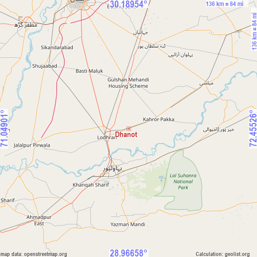
Dhanot GPS coordinates[2]
29° 34' 47.676" North, 71° 45' 7.668" East
| Map corner | latitude | longitude |
|---|---|---|
| Upper-left | 30.18954°, | 71.04901° |
| Center: | 29.57991°, | 71.75213° |
| Lower-right: | 28.96658°, | 72.45526° |
| Map W x H: | 136×136 km | = 84.5×84.5mi |
| max Lat: | 36.32162° ⇑62.8% North |
| Dhanot: | 29.57991° |
| min Lat: | ⇓37.2% South 24.14422° |
| min Long | Dhanot | max Long |
| 61.74573° | 71.75213° | 75.63372° |
| W 53.5%⇐ | ⇒46.5% E |
Elevation
Elevation of Dhanot is 120 m = 394 ft, and this is 225 m = 738 ft below average elevation for this country.
| Max E: |
2732 m = 8963 ft | 66.6% |
| Avg. | 345 m = 1132 ft | |
| Dhanot | 120 m = 394 ft | |
Min E: |
3 m = 10 ft | 33.4% |
See also: Pakistan elevation on elevation.city.
Geographical zone
Dhanot is located in North temperate zone (between Tropic of Cancer and the Arctic Circle). Distance of this Northern Tropic circle is 683.1 km =424.5 mi to South.| Distance of | km | miles | from Dhanot |
|---|---|---|---|
| North Pole | 6718.1 | 4174.4 | to North |
| Arctic Circle | 4112.2 | 2555.2 | to North |
| Tropic Cancer | 683.1 | 424.5 | to South |
| Equator | 3289 | 2043.7 | to South |


Nearby cities:
15 places around Dhanot: (largest is in red/bold)
• Ahmadpur East
68.3 km =42.4 mi,  224°
224°
• Bahawalpur
21.6 km =13.4 mi,  200°
200°
• Dunyapur
24.8 km =15.4 mi,  358°
358°
• Hasilpur
77.7 km =48.3 mi,  80°
80°
• Jalalpur Pirwala
51.9 km =32.2 mi,  260°
260°
• Kahror Pakka
16.4 km =10.2 mi,  72°
72°
• Khairpur Tamewah
47 km =29.2 mi,  89°
89°
• Khangarh
68.1 km =42.3 mi,  303°
303°
• Lodhran
12.7 km =7.9 mi,  246°
246°
• Mailsi
47.6 km =29.6 mi,  58°
58°
• Multan
73.5 km =45.7 mi,  338°
338°
• Muzaffargarh
76.8 km =47.7 mi,  315°
315°
• Shahr Sultan
70.6 km =43.9 mi,  269°
269°
• Shujaabad
55.5 km =34.5 mi,  307°
307°
• Yazman
51 km =31.7 mi,  180°
180°
Sources, notices
• [Note1] Compared only with cities in Pakistan existing in our database
• [Src1] Map data: © OpenStreetMap contributors (CC-BY-SA)
• [Src2] Other city data from geonames.org with taken over terms of usage.
• [Src3] Geographical zone / Annual Mean Temperature by Robert A. Rohde @ Wikipedia
