Ahmadpur East geodata
Ahmadpur East (Punjab) is a populated place; located in Pakistan in Asia/Karachi (GMT+5) time zone. With population of 116,579 people, there are 59 cities with bigger population in this country. Compared to other cities in Pakistan, 65.7% of cities are located further ↑North; 51.9% of cities are located further →East and 68.2% of cities have higher elevation than Ahmadpur East. Note1


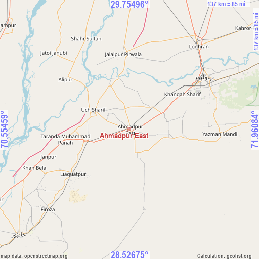
Ahmadpur East GPS coordinates[2]
29° 8' 33.684" North, 71° 15' 27.756" East
| Map corner | latitude | longitude |
|---|---|---|
| Upper-left | 29.75496°, | 70.55459° |
| Center: | 29.14269°, | 71.25771° |
| Lower-right: | 28.52675°, | 71.96084° |
| Map W x H: | 136.6×136.6 km | = 84.9×84.9mi |
| max Lat: | 36.32162° ⇑65.7% North |
| Ahmadpur East: | 29.14269° |
| min Lat: | ⇓34.3% South 24.14422° |
| min Long | Ahmadpur East | max Long |
| 61.74573° | 71.25771° | 75.63372° |
| W 48.1%⇐ | ⇒51.9% E |
Elevation
Elevation of Ahmadpur East is 105 m = 344 ft, and this is 240 m = 787 ft below average elevation for this country.
| Max E: |
2732 m = 8963 ft | 68.2% |
| Avg. | 345 m = 1132 ft | |
| Ahmadpur East | 105 m = 344 ft | |
Min E: |
3 m = 10 ft | 31.8% |
See also: Ahmadpur East elevation on elevation.city.
Geographical zone
Ahmadpur East is located in North temperate zone (between Tropic of Cancer and the Arctic Circle). Distance of this Northern Tropic circle is 634.4 km =394.2 mi to South.| Distance of | km | miles | from Ahmadpur East |
|---|---|---|---|
| North Pole | 6766.7 | 4204.6 | to North |
| Arctic Circle | 4160.8 | 2585.4 | to North |
| Tropic Cancer | 634.4 | 394.2 | to South |
| Equator | 3240.4 | 2013.5 | to South |


Nearby cities:
15 places around Ahmadpur East: (largest is in red/bold)
• Alipur
42.9 km =26.7 mi,  308°
308°
• Bahawalpur
49.4 km =30.7 mi,  54°
54°
• Dhanot
68.3 km =42.4 mi,  44°
44°
• Dunyapur
87.2 km =54.2 mi,  32°
32°
• Jalalpur Pirwala
40.4 km =25.1 mi,  355°
355°
• Jampur
84.9 km =52.8 mi, 310°
• Jatoi Shimali
57.8 km =35.9 mi,  316°
316°
• Kahror Pakka
83.2 km =51.7 mi, 49°
• Khangarh
86.3 km =53.6 mi,  353°
353°
• Khanpur
80.3 km =49.9 mi,  226°
226°
• Lodhran
56.7 km =35.2 mi, 39°
• Shahr Sultan
53.2 km =33.1 mi,  334°
334°
• Shujaabad
82.2 km =51.1 mi,  2°
2°
• Yazman
47.3 km =29.4 mi,  92°
92°
• Zahir Pir
80.3 km =49.9 mi,  242°
242°
Sources, notices
• [Note1] Compared only with cities in Pakistan existing in our database
• [Src1] Map data: © OpenStreetMap contributors (CC-BY-SA)
• [Src2] Other city data from geonames.org with taken over terms of usage.
• [Src3] Geographical zone / Annual Mean Temperature by Robert A. Rohde @ Wikipedia
