Bahawalpur geodata
Bahawalpur (Punjab) is a seat of a second-order administrative division; located in Pakistan in Asia/Karachi (GMT+5) time zone. With population of 552,607 people, there are 14 cities with bigger population in this country. Compared to other cities in Pakistan, 65% of cities are located further ↑North; 52.4% of cities are located further ←West and 65.7% of cities have higher elevation than Bahawalpur. Note1


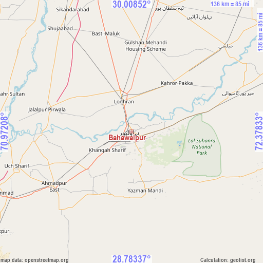
Bahawalpur GPS coordinates[2]
29° 23' 52.044" North, 71° 40' 30.72" East
| Map corner | latitude | longitude |
|---|---|---|
| Upper-left | 30.00852°, | 70.97208° |
| Center: | 29.39779°, | 71.6752° |
| Lower-right: | 28.78337°, | 72.37833° |
| Map W x H: | 136.2×136.2 km | = 84.6×84.6mi |
| max Lat: | 36.32162° ⇑65% North |
| Bahawalpur: | 29.39779° |
| min Lat: | ⇓35% South 24.14422° |
| min Long | Bahawalpur | max Long |
| 61.74573° | 71.6752° | 75.63372° |
| W 52.4%⇐ | ⇒47.6% E |
Elevation
Elevation of Bahawalpur is 121 m = 397 ft, and this is 224 m = 735 ft below average elevation for this country.
| Max E: |
2732 m = 8963 ft | 65.7% |
| Avg. | 345 m = 1132 ft | |
| Bahawalpur | 121 m = 397 ft | |
Min E: |
3 m = 10 ft | 34.3% |
See also: Bahawalpur elevation on elevation.city.
Geographical zone
Bahawalpur is located in North temperate zone (between Tropic of Cancer and the Arctic Circle). Distance of this Northern Tropic circle is 662.8 km =411.8 mi to South.| Distance of | km | miles | from Bahawalpur |
|---|---|---|---|
| North Pole | 6738.3 | 4187 | to North |
| Arctic Circle | 4132.4 | 2567.8 | to North |
| Tropic Cancer | 662.8 | 411.8 | to South |
| Equator | 3268.7 | 2031.1 | to South |


Nearby cities:
15 places around Bahawalpur: (largest is in red/bold)
• Ahmadpur East
49.4 km =30.7 mi,  234°
234°
• Alipur
74 km =46 mi,  268°
268°
• Dhanot
21.6 km =13.4 mi,  20°
20°
• Dunyapur
45.5 km =28.3 mi,  8°
8°
• Jalalpur Pirwala
45.5 km =28.3 mi,  285°
285°
• Jatoi Shimali
81.5 km =50.6 mi,  279°
279°
• Kahror Pakka
34.2 km =21.3 mi,  42°
42°
• Khairpur Tamewah
58.2 km =36.2 mi,  69°
69°
• Khangarh
76 km =47.2 mi,  319°
319°
• Lodhran
15.7 km =9.8 mi,  344°
344°
• Mailsi
65.9 km =40.9 mi,  47°
47°
• Muzaffargarh
88.3 km =54.9 mi,  328°
328°
• Shahr Sultan
66.2 km =41.1 mi, 287°
• Shujaabad
65.2 km =40.5 mi, 325°
• Yazman
31.5 km =19.6 mi,  167°
167°
Sources, notices
• [Note1] Compared only with cities in Pakistan existing in our database
• [Src1] Map data: © OpenStreetMap contributors (CC-BY-SA)
• [Src2] Other city data from geonames.org with taken over terms of usage.
• [Src3] Geographical zone / Annual Mean Temperature by Robert A. Rohde @ Wikipedia
