Mianwali geodata
Mianwali (Punjab) is a seat of a second-order administrative division; located in Pakistan in Asia/Karachi (GMT+5) time zone. With population of 89,570 people, there are 72 cities with bigger population in this country. Compared to other cities in Pakistan, 76.5% of cities are located further ↓South; 50.3% of cities are located further ←West and 60.7% of cities have lower elevation than Mianwali. Note1


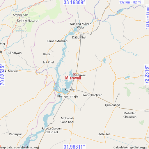
Mianwali GPS coordinates[2]
32° 34' 39.216" North, 71° 31' 42.492" East
| Map corner | latitude | longitude |
|---|---|---|
| Upper-left | 33.16809°, | 70.82535° |
| Center: | 32.57756°, | 71.52847° |
| Lower-right: | 31.98311°, | 72.2316° |
| Map W x H: | 131.8×131.8 km | = 81.9×81.9mi |
| max Lat: | 36.32162° ⇑23.5% North |
| Mianwali: | 32.57756° |
| min Lat: | ⇓76.5% South 24.14422° |
| min Long | Mianwali | max Long |
| 61.74573° | 71.52847° | 75.63372° |
| W 50.3%⇐ | ⇒49.7% E |
Elevation
Elevation of Mianwali is 208 m = 682 ft, and this is 137 m = 449 ft below average elevation for this country.
| Max E: |
2732 m = 8963 ft | 39.3% |
| Avg. | 345 m = 1132 ft | |
| Mianwali | 208 m = 682 ft | |
Min E: |
3 m = 10 ft | 60.7% |
See also: Mianwali elevation on elevation.city.
Geographical zone
Mianwali is located in North temperate zone (between Tropic of Cancer and the Arctic Circle). Distance of this Northern Tropic circle is 1016.4 km =631.6 mi to South.| Distance of | km | miles | from Mianwali |
|---|---|---|---|
| North Pole | 6384.8 | 3967.3 | to North |
| Arctic Circle | 3778.9 | 2348.1 | to North |
| Tropic Cancer | 1016.4 | 631.6 | to South |
| Equator | 3622.3 | 2250.8 | to South |


Nearby cities:
15 places around Mianwali: (largest is in red/bold)
• Daud Khel
33.3 km =20.7 mi,  6°
6°
• Dullewala
83.1 km =51.6 mi,  185°
185°
• Harnoli
33.3 km =20.7 mi,  175°
175°
• Jauharabad
77.6 km =48.2 mi,  114°
114°
• Kalabagh
42.7 km =26.5 mi,  2°
2°
• Kalur Kot
53 km =32.9 mi,  207°
207°
• Kamar Mushani
33.4 km =20.8 mi,  332°
332°
• Karak
72.4 km =45 mi, 325°
• Khushāb
83.4 km =51.8 mi, 111°
• Kundian
14.1 km =8.8 mi,  199°
199°
• Lachi
91.3 km =56.7 mi,  348°
348°
• Lakki
57.8 km =35.9 mi,  273°
273°
• Mitha Tiwana
65.6 km =40.8 mi,  124°
124°
• Paharpur
74.2 km =46.1 mi,  224°
224°
• Sarai Naurang
75.2 km =46.7 mi,  291°
291°
Sources, notices
• [Note1] Compared only with cities in Pakistan existing in our database
• [Src1] Map data: © OpenStreetMap contributors (CC-BY-SA)
• [Src2] Other city data from geonames.org with taken over terms of usage.
• [Src3] Geographical zone / Annual Mean Temperature by Robert A. Rohde @ Wikipedia
