Dullewala geodata
Dullewala (Punjab) is a populated place; located in Pakistan in Asia/Karachi (GMT+5) time zone. With population of 48,682 people, there are 133 cities with bigger population in this country. Compared to other cities in Pakistan, 63.7% of cities are located further ↓South; 50.8% of cities are located further →East and 51.9% of cities have lower elevation than Dullewala. Note1


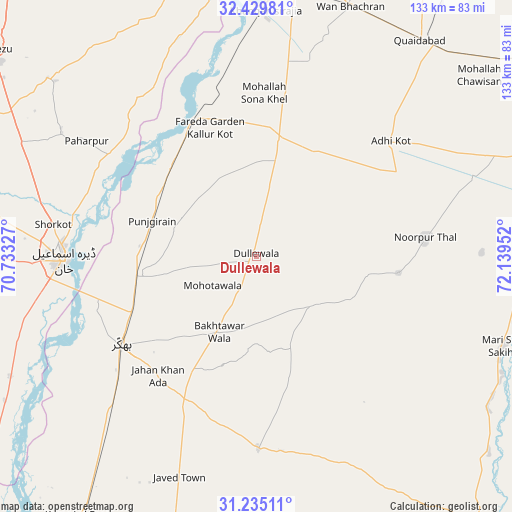
Dullewala GPS coordinates[2]
31° 50' 3.804" North, 71° 26' 11.004" East
| Map corner | latitude | longitude |
|---|---|---|
| Upper-left | 32.42981°, | 70.73327° |
| Center: | 31.83439°, | 71.43639° |
| Lower-right: | 31.23511°, | 72.13952° |
| Map W x H: | 132.8×132.8 km | = 82.5×82.5mi |
| max Lat: | 36.32162° ⇑36.3% North |
| Dullewala: | 31.83439° |
| min Lat: | ⇓63.7% South 24.14422° |
| min Long | Dullewala | max Long |
| 61.74573° | 71.43639° | 75.63372° |
| W 49.2%⇐ | ⇒50.8% E |
Elevation
Elevation of Dullewala is 183 m = 600 ft, and this is 162 m = 531 ft below average elevation for this country.
| Max E: |
2732 m = 8963 ft | 48.1% |
| Avg. | 345 m = 1132 ft | |
| Dullewala | 183 m = 600 ft | |
Min E: |
3 m = 10 ft | 51.9% |
See also: Dullewala elevation on elevation.city.
Geographical zone
Dullewala is located in North temperate zone (between Tropic of Cancer and the Arctic Circle). Distance of this Northern Tropic circle is 933.7 km =580.2 mi to South.| Distance of | km | miles | from Dullewala |
|---|---|---|---|
| North Pole | 6467.4 | 4018.7 | to North |
| Arctic Circle | 3861.5 | 2399.4 | to North |
| Tropic Cancer | 933.7 | 580.2 | to South |
| Equator | 3539.7 | 2199.5 | to South |


Nearby cities:
15 places around Dullewala: (largest is in red/bold)
• Bhakkar
42 km =26.1 mi,  236°
236°
• Chak Two Hundred Forty-nine Thal Development Authority
76.2 km =47.3 mi,  196°
196°
• Darya Khan
32.1 km =19.9 mi,  260°
260°
• Dera Ismail Khan
50.5 km =31.4 mi,  269°
269°
• Harnoli
50.6 km =31.4 mi,  12°
12°
• Jahanian Shah
79.5 km =49.4 mi,  92°
92°
• Kalur Kot
39.1 km =24.3 mi,  335°
335°
• Karor
81.9 km =50.9 mi,  214°
214°
• Kundian
69.4 km =43.1 mi,  3°
3°
• Mankera
49.7 km =30.9 mi,  179°
179°
• Mianwali
83.1 km =51.6 mi, 5°
• Mitha Tiwana
77.9 km =48.4 mi,  54°
54°
• Paharpur
53.3 km =33.1 mi,  304°
304°
• Sahiwal
85.9 km =53.4 mi,  79°
79°
• Shorkot
53.4 km =33.2 mi,  279°
279°
Sources, notices
• [Note1] Compared only with cities in Pakistan existing in our database
• [Src1] Map data: © OpenStreetMap contributors (CC-BY-SA)
• [Src2] Other city data from geonames.org with taken over terms of usage.
• [Src3] Geographical zone / Annual Mean Temperature by Robert A. Rohde @ Wikipedia
