Paharpur geodata
Paharpur (Khyber Pakhtunkhwa) is a populated place; located in Pakistan in Asia/Karachi (GMT+5) time zone. With population of 17,294 people, there are 290 cities with bigger population in this country. Compared to other cities in Pakistan, 67.5% of cities are located further ↓South; 54.6% of cities are located further →East and 51% of cities have lower elevation than Paharpur. Note1


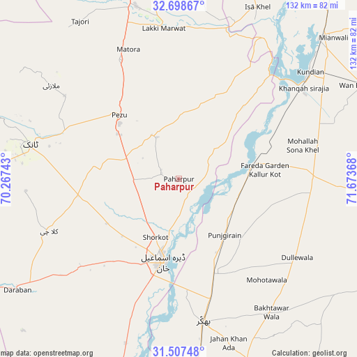
Paharpur GPS coordinates[2]
32° 6' 18.072" North, 70° 58' 13.98" East
| Map corner | latitude | longitude |
|---|---|---|
| Upper-left | 32.69867°, | 70.26743° |
| Center: | 32.10502°, | 70.97055° |
| Lower-right: | 31.50748°, | 71.67368° |
| Map W x H: | 132.4×132.4 km | = 82.3×82.3mi |
| max Lat: | 36.32162° ⇑32.5% North |
| Paharpur: | 32.10502° |
| min Lat: | ⇓67.5% South 24.14422° |
| min Long | Paharpur | max Long |
| 61.74573° | 70.97055° | 75.63372° |
| W 45.4%⇐ | ⇒54.6% E |
Elevation
Elevation of Paharpur is 182 m = 597 ft, and this is 163 m = 535 ft below average elevation for this country.
| Max E: |
2732 m = 8963 ft | 49% |
| Avg. | 345 m = 1132 ft | |
| Paharpur | 182 m = 597 ft | |
Min E: |
3 m = 10 ft | 51% |
See also: Pakistan elevation on elevation.city.
Geographical zone
Paharpur is located in North temperate zone (between Tropic of Cancer and the Arctic Circle). Distance of this Northern Tropic circle is 963.8 km =598.9 mi to South.| Distance of | km | miles | from Paharpur |
|---|---|---|---|
| North Pole | 6437.3 | 4000 | to North |
| Arctic Circle | 3831.4 | 2380.7 | to North |
| Tropic Cancer | 963.8 | 598.9 | to South |
| Equator | 3569.7 | 2218.1 | to South |


Nearby cities:
15 places around Paharpur: (largest is in red/bold)
• Bhakkar
53.9 km =33.5 mi,  170°
170°
• Darya Khan
37.7 km =23.4 mi,  160°
160°
• Dera Ismail Khan
31.1 km =19.3 mi,  192°
192°
• Dullewala
53.3 km =33.1 mi,  124°
124°
• Gulishah Kach
86.4 km =53.7 mi,  316°
316°
• Harnoli
58.2 km =36.2 mi,  70°
70°
• Kalur Kot
28.4 km =17.6 mi,  78°
78°
• Kamar Mushani
89.9 km =55.9 mi,  24°
24°
• Kulachi
51.9 km =32.2 mi,  248°
248°
• Kundian
61.8 km =38.4 mi,  50°
50°
• Lakki
56.1 km =34.9 mi,  354°
354°
• Mianwali
74.2 km =46.1 mi,  44°
44°
• Sarai Naurang
82.1 km =51 mi, 347°
• Shorkot
23.4 km =14.5 mi,  202°
202°
• Tank
56.7 km =35.2 mi,  282°
282°
Sources, notices
• [Note1] Compared only with cities in Pakistan existing in our database
• [Src1] Map data: © OpenStreetMap contributors (CC-BY-SA)
• [Src2] Other city data from geonames.org with taken over terms of usage.
• [Src3] Geographical zone / Annual Mean Temperature by Robert A. Rohde @ Wikipedia
