Harnoli geodata
Harnoli (Punjab) is a populated place; located in Pakistan in Asia/Karachi (GMT+5) time zone. With population of 15,669 people, there are 309 cities with bigger population in this country. Compared to other cities in Pakistan, 70.9% of cities are located further ↓South; 50.8% of cities are located further ←West and 56.2% of cities have lower elevation than Harnoli. Note1


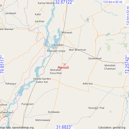
Harnoli GPS coordinates[2]
32° 16' 43.356" North, 71° 33' 15.444" East
| Map corner | latitude | longitude |
|---|---|---|
| Upper-left | 32.87122°, | 70.85117° |
| Center: | 32.27871°, | 71.55429° |
| Lower-right: | 31.6823°, | 72.25742° |
| Map W x H: | 132.2×132.2 km | = 82.1×82.1mi |
| max Lat: | 36.32162° ⇑29.1% North |
| Harnoli: | 32.27871° |
| min Lat: | ⇓70.9% South 24.14422° |
| min Long | Harnoli | max Long |
| 61.74573° | 71.55429° | 75.63372° |
| W 50.8%⇐ | ⇒49.2% E |
Elevation
Elevation of Harnoli is 194 m = 636 ft, and this is 151 m = 495 ft below average elevation for this country.
| Max E: |
2732 m = 8963 ft | 43.8% |
| Avg. | 345 m = 1132 ft | |
| Harnoli | 194 m = 636 ft | |
Min E: |
3 m = 10 ft | 56.2% |
See also: Pakistan elevation on elevation.city.
Geographical zone
Harnoli is located in North temperate zone (between Tropic of Cancer and the Arctic Circle). Distance of this Northern Tropic circle is 983.1 km =610.9 mi to South.| Distance of | km | miles | from Harnoli |
|---|---|---|---|
| North Pole | 6418 | 3988 | to North |
| Arctic Circle | 3812.1 | 2368.7 | to North |
| Tropic Cancer | 983.1 | 610.9 | to South |
| Equator | 3589.1 | 2230.2 | to South |


Nearby cities:
15 places around Harnoli: (largest is in red/bold)
• Darya Khan
69.6 km =43.2 mi,  217°
217°
• Daud Khel
66.4 km =41.3 mi,  1°
1°
• Dera Ismail Khan
79.1 km =49.2 mi,  231°
231°
• Dullewala
50.6 km =31.4 mi,  192°
192°
• Jauharabad
68.4 km =42.5 mi,  88°
88°
• Kalabagh
75.9 km =47.2 mi,  359°
359°
• Kalur Kot
30.4 km =18.9 mi,  243°
243°
• Kamar Mushani
65.3 km =40.6 mi,  343°
343°
• Khushāb
75.1 km =46.7 mi, 88°
• Kundian
21.1 km =13.1 mi, 340°
• Lakki
70.4 km =43.7 mi,  301°
301°
• Mianwali
33.3 km =20.7 mi, 355°
• Mitha Tiwana
52 km =32.3 mi, 94°
• Paharpur
58.2 km =36.2 mi,  250°
250°
• Shorkot
75.8 km =47.1 mi, 237°
Sources, notices
• [Note1] Compared only with cities in Pakistan existing in our database
• [Src1] Map data: © OpenStreetMap contributors (CC-BY-SA)
• [Src2] Other city data from geonames.org with taken over terms of usage.
• [Src3] Geographical zone / Annual Mean Temperature by Robert A. Rohde @ Wikipedia
