Kundian geodata
Kundian (Punjab) is a populated place; located in Pakistan in Asia/Karachi (GMT+5) time zone. With population of 35,406 people, there are 175 cities with bigger population in this country. Compared to other cities in Pakistan, 74.5% of cities are located further ↓South; 50.1% of cities are located further ←West and 59.6% of cities have lower elevation than Kundian. Note1


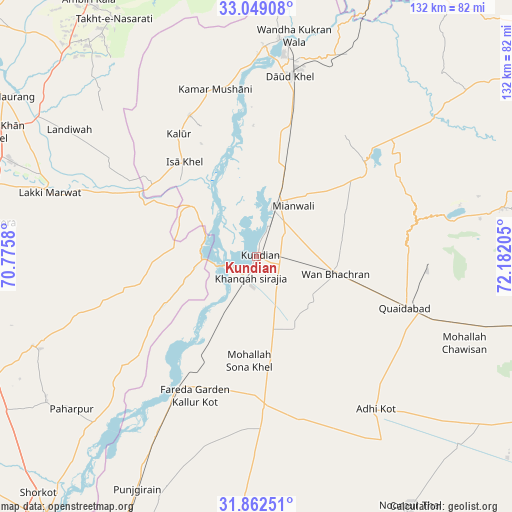
Kundian GPS coordinates[2]
32° 27' 27.9" North, 71° 28' 44.112" East
| Map corner | latitude | longitude |
|---|---|---|
| Upper-left | 33.04908°, | 70.7758° |
| Center: | 32.45775°, | 71.47892° |
| Lower-right: | 31.86251°, | 72.18205° |
| Map W x H: | 131.9×131.9 km | = 82×82mi |
| max Lat: | 36.32162° ⇑25.5% North |
| Kundian: | 32.45775° |
| min Lat: | ⇓74.5% South 24.14422° |
| min Long | Kundian | max Long |
| 61.74573° | 71.47892° | 75.63372° |
| W 50.1%⇐ | ⇒49.9% E |
Elevation
Elevation of Kundian is 203 m = 666 ft, and this is 142 m = 466 ft below average elevation for this country.
| Max E: |
2732 m = 8963 ft | 40.4% |
| Avg. | 345 m = 1132 ft | |
| Kundian | 203 m = 666 ft | |
Min E: |
3 m = 10 ft | 59.6% |
See also: Pakistan elevation on elevation.city.
Geographical zone
Kundian is located in North temperate zone (between Tropic of Cancer and the Arctic Circle). Distance of this Northern Tropic circle is 1003 km =623.2 mi to South.| Distance of | km | miles | from Kundian |
|---|---|---|---|
| North Pole | 6398.1 | 3975.6 | to North |
| Arctic Circle | 3792.2 | 2356.4 | to North |
| Tropic Cancer | 1003 | 623.2 | to South |
| Equator | 3609 | 2242.5 | to South |


Nearby cities:
15 places around Kundian: (largest is in red/bold)
• Darya Khan
82.9 km =51.5 mi,  205°
205°
• Daud Khel
47.2 km =29.3 mi,  10°
10°
• Dullewala
69.4 km =43.1 mi,  183°
183°
• Harnoli
21.1 km =13.1 mi,  160°
160°
• Jauharabad
77.7 km =48.3 mi,  103°
103°
• Kalabagh
56.4 km =35 mi, 6°
• Kalur Kot
39.1 km =24.3 mi, 210°
• Kamar Mushani
44.2 km =27.5 mi,  345°
345°
• Karak
81.6 km =50.7 mi,  333°
333°
• Lakki
55.7 km =34.6 mi,  287°
287°
• Mianwali
14.1 km =8.8 mi,  19°
19°
• Mitha Tiwana
63.5 km =39.5 mi,  111°
111°
• Paharpur
61.8 km =38.4 mi,  230°
230°
• Sarai Naurang
77.1 km =47.9 mi,  302°
302°
• Shorkot
83.1 km =51.6 mi,  222°
222°
Sources, notices
• [Note1] Compared only with cities in Pakistan existing in our database
• [Src1] Map data: © OpenStreetMap contributors (CC-BY-SA)
• [Src2] Other city data from geonames.org with taken over terms of usage.
• [Src3] Geographical zone / Annual Mean Temperature by Robert A. Rohde @ Wikipedia
