Kalur Kot geodata
Kalur Kot (Punjab) is a populated place; located in Pakistan in Asia/Karachi (GMT+5) time zone. With population of 25,574 people, there are 238 cities with bigger population in this country. Compared to other cities in Pakistan, 67.7% of cities are located further ↓South; 51.7% of cities are located further →East and 55.3% of cities have lower elevation than Kalur Kot. Note1


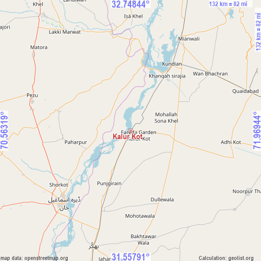
Kalur Kot GPS coordinates[2]
32° 9' 18.432" North, 71° 15' 58.716" East
| Map corner | latitude | longitude |
|---|---|---|
| Upper-left | 32.74844°, | 70.56319° |
| Center: | 32.15512°, | 71.26631° |
| Lower-right: | 31.55791°, | 71.96944° |
| Map W x H: | 132.4×132.4 km | = 82.3×82.3mi |
| max Lat: | 36.32162° ⇑32.3% North |
| Kalur Kot: | 32.15512° |
| min Lat: | ⇓67.7% South 24.14422° |
| min Long | Kalur Kot | max Long |
| 61.74573° | 71.26631° | 75.63372° |
| W 48.3%⇐ | ⇒51.7% E |
Elevation
Elevation of Kalur Kot is 191 m = 627 ft, and this is 154 m = 505 ft below average elevation for this country.
| Max E: |
2732 m = 8963 ft | 44.7% |
| Avg. | 345 m = 1132 ft | |
| Kalur Kot | 191 m = 627 ft | |
Min E: |
3 m = 10 ft | 55.3% |
See also: Pakistan elevation on elevation.city.
Geographical zone
Kalur Kot is located in North temperate zone (between Tropic of Cancer and the Arctic Circle). Distance of this Northern Tropic circle is 969.4 km =602.4 mi to South.| Distance of | km | miles | from Kalur Kot |
|---|---|---|---|
| North Pole | 6431.7 | 3996.5 | to North |
| Arctic Circle | 3825.9 | 2377.3 | to North |
| Tropic Cancer | 969.4 | 602.4 | to South |
| Equator | 3575.3 | 2221.6 | to South |


Nearby cities:
15 places around Kalur Kot: (largest is in red/bold)
• Bhakkar
61.7 km =38.3 mi,  197°
197°
• Darya Khan
44 km =27.3 mi, 200°
• Daud Khel
85 km =52.8 mi,  19°
19°
• Dera Ismail Khan
49.8 km =30.9 mi,  223°
223°
• Dullewala
39.1 km =24.3 mi,  155°
155°
• Harnoli
30.4 km =18.9 mi,  63°
63°
• Kamar Mushani
77 km =47.8 mi,  6°
6°
• Kulachi
80 km =49.7 mi,  251°
251°
• Kundian
39.1 km =24.3 mi,  30°
30°
• Lakki
60.3 km =37.5 mi,  326°
326°
• Mianwali
53 km =32.9 mi, 27°
• Mitha Tiwana
79.7 km =49.5 mi,  82°
82°
• Paharpur
28.4 km =17.6 mi,  258°
258°
• Shorkot
45.7 km =28.4 mi,  233°
233°
• Tank
83.4 km =51.8 mi,  274°
274°
Sources, notices
• [Note1] Compared only with cities in Pakistan existing in our database
• [Src1] Map data: © OpenStreetMap contributors (CC-BY-SA)
• [Src2] Other city data from geonames.org with taken over terms of usage.
• [Src3] Geographical zone / Annual Mean Temperature by Robert A. Rohde @ Wikipedia
