Nushki geodata
Nushki (Balochistan) is a populated place; located in Pakistan in Asia/Karachi (GMT+5) time zone. With population of 27,680 people, there are 223 cities with bigger population in this country. Compared to other cities in Pakistan, 63.4% of cities are located further ↑North; 98% of cities are located further →East and 89.2% of cities have lower elevation than Nushki. Note1


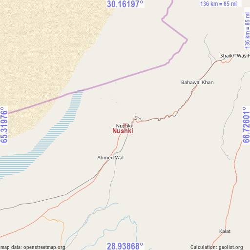
Nushki GPS coordinates[2]
29° 33' 7.848" North, 66° 1' 22.368" East
| Map corner | latitude | longitude |
|---|---|---|
| Upper-left | 30.16197°, | 65.31976° |
| Center: | 29.55218°, | 66.02288° |
| Lower-right: | 28.93868°, | 66.72601° |
| Map W x H: | 136×136 km | = 84.5×84.5mi |
| max Lat: | 36.32162° ⇑63.4% North |
| Nushki: | 29.55218° |
| min Lat: | ⇓36.6% South 24.14422° |
| min Long | Nushki | max Long |
| 61.74573° | 66.02288° | 75.63372° |
| W 2%⇐ | ⇒98% E |
Elevation
Elevation of Nushki is 997 m = 3271 ft, and this is 652 m = 2139 ft above average elevation for this country.
| Max E: |
2732 m = 8963 ft | 10.8% |
| Nushki | 997 m 3271 ft | |
| Avg. | 345 m = 1132 ft | |
Min E: |
3 m = 10 ft | 89.2% |
See also: Pakistan elevation on elevation.city.
Geographical zone
Nushki is located in North temperate zone (between Tropic of Cancer and the Arctic Circle). Distance of this Northern Tropic circle is 680 km =422.5 mi to South.| Distance of | km | miles | from Nushki |
|---|---|---|---|
| North Pole | 6721.2 | 4176.4 | to North |
| Arctic Circle | 4115.3 | 2557.1 | to North |
| Tropic Cancer | 680 | 422.5 | to South |
| Equator | 3285.9 | 2041.8 | to South |


Nearby cities:
15 places around Nushki: (largest is in red/bold)
• Alik Ghund
178 km =110.6 mi,  54°
54°
• Chaman
157.3 km =97.7 mi,  15°
15°
• Dadhar
157.8 km =98.1 mi,  93°
93°
• Dalbandin
173.4 km =107.7 mi,  244°
244°
• Gandava
176.4 km =109.6 mi,  126°
126°
• Kalat
80.5 km =50 mi,  136°
136°
• Kharan
122.7 km =76.2 mi,  208°
208°
• Kot Malik Barkhurdar
117.9 km =73.3 mi, 52°
• Mach
130.9 km =81.3 mi,  74°
74°
• Mastung
84.1 km =52.3 mi, 70°
• Pishin
147.8 km =91.8 mi,  39°
39°
• Qila Abdullah
144.4 km =89.7 mi,  25°
25°
• Quetta
117.6 km =73.1 mi, 53°
• Sibi
179.4 km =111.5 mi, 90°
• Surab
120 km =74.6 mi,  168°
168°
Sources, notices
• [Note1] Compared only with cities in Pakistan existing in our database
• [Src1] Map data: © OpenStreetMap contributors (CC-BY-SA)
• [Src2] Other city data from geonames.org with taken over terms of usage.
• [Src3] Geographical zone / Annual Mean Temperature by Robert A. Rohde @ Wikipedia
