Dajal geodata
Dajal (Punjab) is a populated place; located in Pakistan in Asia/Karachi (GMT+5) time zone. With population of 17,630 people, there are 287 cities with bigger population in this country. Compared to other cities in Pakistan, 63.2% of cities are located further ↑North; 60.7% of cities are located further →East and 64.8% of cities have higher elevation than Dajal. Note1


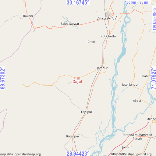
Dajal GPS coordinates[2]
29° 33' 27.684" North, 70° 22' 34.104" East
| Map corner | latitude | longitude |
|---|---|---|
| Upper-left | 30.16745°, | 69.67302° |
| Center: | 29.55769°, | 70.37614° |
| Lower-right: | 28.94423°, | 71.07927° |
| Map W x H: | 136×136 km | = 84.5×84.5mi |
| max Lat: | 36.32162° ⇑63.2% North |
| Dajal: | 29.55769° |
| min Lat: | ⇓36.8% South 24.14422° |
| min Long | Dajal | max Long |
| 61.74573° | 70.37614° | 75.63372° |
| W 39.3%⇐ | ⇒60.7% E |
Elevation
Elevation of Dajal is 124 m = 407 ft, and this is 221 m = 725 ft below average elevation for this country.
| Max E: |
2732 m = 8963 ft | 64.8% |
| Avg. | 345 m = 1132 ft | |
| Dajal | 124 m = 407 ft | |
Min E: |
3 m = 10 ft | 35.2% |
See also: Pakistan elevation on elevation.city.
Geographical zone
Dajal is located in North temperate zone (between Tropic of Cancer and the Arctic Circle). Distance of this Northern Tropic circle is 680.6 km =422.9 mi to South.| Distance of | km | miles | from Dajal |
|---|---|---|---|
| North Pole | 6720.6 | 4176 | to North |
| Arctic Circle | 4114.7 | 2556.8 | to North |
| Tropic Cancer | 680.6 | 422.9 | to South |
| Equator | 3286.5 | 2042.1 | to South |


Nearby cities:
15 places around Dajal: (largest is in red/bold)
• Ahmadpur East
97.1 km =60.3 mi,  118°
118°
• Alipur
55.3 km =34.4 mi,  110°
110°
• Barkhan
90.4 km =56.2 mi,  294°
294°
• Dera Ghazi Khan
60 km =37.3 mi,  25°
25°
• Jalalpur Pirwala
82 km =51 mi,  94°
94°
• Jampur
23.2 km =14.4 mi,  66°
66°
• Jatoi Shimali
45.5 km =28.3 mi,  95°
95°
• Khangarh
85.5 km =53.1 mi,  62°
62°
• Khanpur
104.8 km =65.1 mi,  164°
164°
• Muzaffargarh
97.5 km =60.6 mi,  54°
54°
• Rajanpur
50.6 km =31.4 mi,  185°
185°
• Rojhan
105.1 km =65.3 mi,  202°
202°
• Shahr Sultan
62.5 km =38.8 mi, 88°
• Shujaabad
95.6 km =59.4 mi, 67°
• Zahir Pir
84 km =52.2 mi,  170°
170°
Sources, notices
• [Note1] Compared only with cities in Pakistan existing in our database
• [Src1] Map data: © OpenStreetMap contributors (CC-BY-SA)
• [Src2] Other city data from geonames.org with taken over terms of usage.
• [Src3] Geographical zone / Annual Mean Temperature by Robert A. Rohde @ Wikipedia
