Tank geodata
Tank (Khyber Pakhtunkhwa) is a seat of a second-order administrative division; located in Pakistan in Asia/Karachi (GMT+5) time zone. With population of 38,488 people, there are 160 cities with bigger population in this country. Compared to other cities in Pakistan, 69.3% of cities are located further ↓South; 60.5% of cities are located further →East and 72.7% of cities have lower elevation than Tank. Note1


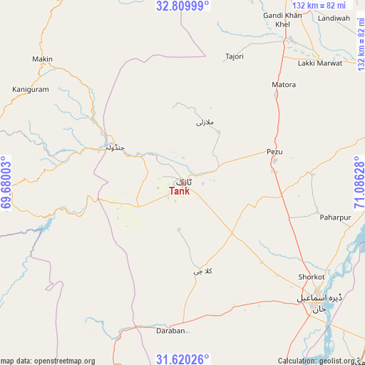
Tank GPS coordinates[2]
32° 13' 1.452" North, 70° 22' 59.34" East
| Map corner | latitude | longitude |
|---|---|---|
| Upper-left | 32.80999°, | 69.68003° |
| Center: | 32.21707°, | 70.38315° |
| Lower-right: | 31.62026°, | 71.08628° |
| Map W x H: | 132.3×132.3 km | = 82.2×82.2mi |
| max Lat: | 36.32162° ⇑30.7% North |
| Tank: | 32.21707° |
| min Lat: | ⇓69.3% South 24.14422° |
| min Long | Tank | max Long |
| 61.74573° | 70.38315° | 75.63372° |
| W 39.5%⇐ | ⇒60.5% E |
Elevation
Elevation of Tank is 259 m = 850 ft, and this is 86 m = 282 ft below average elevation for this country.
| Max E: |
2732 m = 8963 ft | 27.3% |
| Avg. | 345 m = 1132 ft | |
| Tank | 259 m = 850 ft | |
Min E: |
3 m = 10 ft | 72.7% |
See also: Pakistan elevation on elevation.city.
Geographical zone
Tank is located in North temperate zone (between Tropic of Cancer and the Arctic Circle). Distance of this Northern Tropic circle is 976.3 km =606.6 mi to South.| Distance of | km | miles | from Tank |
|---|---|---|---|
| North Pole | 6424.9 | 3992.2 | to North |
| Arctic Circle | 3819 | 2373 | to North |
| Tropic Cancer | 976.3 | 606.6 | to South |
| Equator | 3582.2 | 2225.9 | to South |


Nearby cities:
15 places around Tank: (largest is in red/bold)
• Bannu
87.9 km =54.6 mi,  13°
13°
• Bhakkar
91.9 km =57.1 mi,  135°
135°
• Darya Khan
83.1 km =51.6 mi,  125°
125°
• Dera Ismail Khan
65 km =40.4 mi, 131°
• Dullewala
108 km =67.1 mi,  113°
113°
• Gulishah Kach
50.6 km =31.4 mi,  355°
355°
• Kalur Kot
83.4 km =51.8 mi,  94°
94°
• Kulachi
32.7 km =20.3 mi,  167°
167°
• Kundian
106.4 km =66.1 mi,  75°
75°
• Lakki
66 km =41 mi,  48°
48°
• Miran Shah
91.9 km =57.1 mi,  341°
341°
• Paharpur
56.7 km =35.2 mi,  102°
102°
• Sarai Naurang
77.3 km =48 mi,  28°
28°
• Shorkot
57.7 km =35.9 mi, 126°
• Wana
76.8 km =47.7 mi,  276°
276°
Sources, notices
• [Note1] Compared only with cities in Pakistan existing in our database
• [Src1] Map data: © OpenStreetMap contributors (CC-BY-SA)
• [Src2] Other city data from geonames.org with taken over terms of usage.
• [Src3] Geographical zone / Annual Mean Temperature by Robert A. Rohde @ Wikipedia
