Tuczno geodata
Tuczno (West Pomerania) is a seat of a third-order administrative division; located in Poland in Europe/Warsaw (GMT+2) time zone. With population of 1,919 people, there are 1541 cities with bigger population in this country. Compared to other cities in Poland, 86.3% of cities are located further ↓South; 91.7% of cities are located further →East and 83.7% of cities have higher elevation than Tuczno. Note1


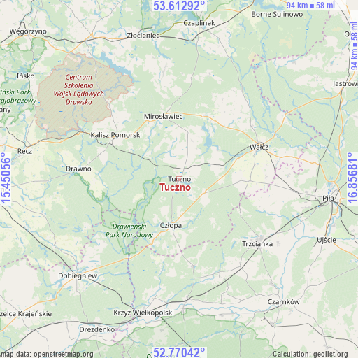
Tuczno GPS coordinates[2]
53° 11' 37.464" North, 16° 9' 13.248" East
| Map corner | latitude | longitude |
|---|---|---|
| Upper-left | 53.61292°, | 15.45056° |
| Center: | 53.19374°, | 16.15368° |
| Lower-right: | 52.77042°, | 16.85681° |
| Map W x H: | 93.7×93.7 km | = 58.2×58.2mi |
| max Lat: | 54.83135° ⇑13.7% North |
| Tuczno: | 53.19374° |
| min Lat: | ⇓86.3% South 49.21328° |
| min Long | Tuczno | max Long |
| 14.20249° | 16.15368° | 24.03723° |
| W 8.3%⇐ | ⇒91.7% E |
Elevation
Elevation of Tuczno is 92 m = 302 ft, and this is 99.4 m = 326 ft below average elevation for this country.
| Max E: |
974 m = 3196 ft | 83.7% |
| Avg. | 191.4 m = 628 ft | |
| Tuczno | 92 m = 302 ft | |
Min E: |
-3 m = -10 ft | 16.3% |
See also: Poland elevation on elevation.city.
Geographical zone
Tuczno is located in North temperate zone (between Tropic of Cancer and the Arctic Circle). Distance of this North polar circle is 1486.6 km =923.7 mi to North.| Distance of | km | miles | from Tuczno |
|---|---|---|---|
| North Pole | 4092.5 | 2543 | to North |
| Arctic Circle | 1486.6 | 923.7 | to North |
| Tropic Cancer | 3308.7 | 2055.9 | to South |
| Equator | 5914.6 | 3675.2 | to South |


Nearby cities:
15 places around Tuczno: (largest is in red/bold)
• Bierzwnik
37 km =23 mi,  241°
241°
• Człopa
11.9 km =7.4 mi,  190°
190°
• Dobiegniew
36.5 km =22.7 mi,  226°
226°
• Drawno
26.4 km =16.4 mi,  276°
276°
• Drawsko
38.6 km =24 mi, 192°
• Kalisz Pomorski
20.2 km =12.6 mi,  305°
305°
• Krzyż Wielkopolski
36.1 km =22.4 mi,  195°
195°
• Mirosławiec
16.9 km =10.5 mi,  345°
345°
• Siedlisko
27.8 km =17.3 mi,  146°
146°
• Skrzatusz
28.5 km =17.7 mi,  87°
87°
• Szydłowo
30.7 km =19.1 mi,  96°
96°
• Trzcianka
26.4 km =16.4 mi,  130°
130°
• Wałcz
23.1 km =14.4 mi,  66°
66°
• Wieleń
33.3 km =20.7 mi,  177°
177°
• Wierzchowo
29.8 km =18.5 mi, 353°
Sources, notices
• [Note1] Compared only with cities in Poland existing in our database
• [Src1] Map data: © OpenStreetMap contributors (CC-BY-SA)
• [Src2] Other city data from geonames.org with taken over terms of usage.
• [Src3] Geographical zone / Annual Mean Temperature by Robert A. Rohde @ Wikipedia
