Mirosławiec geodata
Mirosławiec (West Pomerania) is a seat of a third-order administrative division; located in Poland in Europe/Warsaw (GMT+2) time zone. With population of 2,616 people, there are 1198 cities with bigger population in this country. Compared to other cities in Poland, 87.8% of cities are located further ↓South; 92% of cities are located further →East and 75.8% of cities have higher elevation than Mirosławiec. Note1


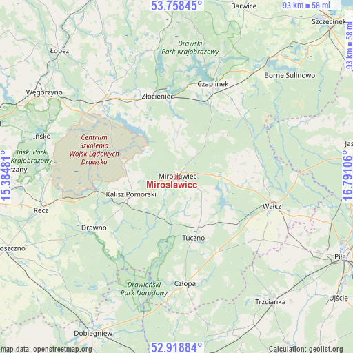
Mirosławiec GPS coordinates[2]
53° 20' 26.556" North, 16° 5' 16.548" East
| Map corner | latitude | longitude |
|---|---|---|
| Upper-left | 53.75845°, | 15.38481° |
| Center: | 53.34071°, | 16.08793° |
| Lower-right: | 52.91884°, | 16.79106° |
| Map W x H: | 93.4×93.4 km | = 58×58mi |
| max Lat: | 54.83135° ⇑12.2% North |
| Mirosławiec: | 53.34071° |
| min Lat: | ⇓87.8% South 49.21328° |
| min Long | Mirosławiec | max Long |
| 14.20249° | 16.08793° | 24.03723° |
| W 8%⇐ | ⇒92% E |
Elevation
Elevation of Mirosławiec is 109 m = 358 ft, and this is 82.4 m = 270 ft below average elevation for this country.
| Max E: |
974 m = 3196 ft | 75.8% |
| Avg. | 191.4 m = 628 ft | |
| Mirosławiec | 109 m = 358 ft | |
Min E: |
-3 m = -10 ft | 24.2% |
See also: Poland elevation on elevation.city.
Geographical zone
Mirosławiec is located in North temperate zone (between Tropic of Cancer and the Arctic Circle). Distance of this North polar circle is 1470.2 km =913.5 mi to North.| Distance of | km | miles | from Mirosławiec |
|---|---|---|---|
| North Pole | 4076.1 | 2532.8 | to North |
| Arctic Circle | 1470.2 | 913.5 | to North |
| Tropic Cancer | 3325 | 2066.1 | to South |
| Equator | 5930.9 | 3685.3 | to South |


Nearby cities:
15 places around Mirosławiec: (largest is in red/bold)
• Borne Sulinowo
39.5 km =24.5 mi,  48°
48°
• Czaplinek
26 km =16.2 mi,  21°
21°
• Człopa
28.1 km =17.5 mi,  175°
175°
• Drawno
25.6 km =15.9 mi,  238°
238°
• Drawsko Pomorskie
28 km =17.4 mi,  318°
318°
• Ińsko
37.2 km =23.1 mi,  286°
286°
• Kalisz Pomorski
12.9 km =8 mi,  249°
249°
• Recz
37 km =23 mi,  255°
255°
• Skrzatusz
36.2 km =22.5 mi,  114°
114°
• Sypniewo
37.1 km =23.1 mi,  67°
67°
• Tuczno
16.9 km =10.5 mi,  165°
165°
• Wałcz
26.4 km =16.4 mi, 105°
• Wierzchowo
13.3 km =8.3 mi,  3°
3°
• Złocieniec
22 km =13.7 mi,  346°
346°
• Łubowo
33.9 km =21.1 mi,  36°
36°
Sources, notices
• [Note1] Compared only with cities in Poland existing in our database
• [Src1] Map data: © OpenStreetMap contributors (CC-BY-SA)
• [Src2] Other city data from geonames.org with taken over terms of usage.
• [Src3] Geographical zone / Annual Mean Temperature by Robert A. Rohde @ Wikipedia
