Świątki geodata
Świątki (Warmia-Masuria) is a populated place; located in Poland in Europe/Warsaw (GMT+2) time zone. With population of 852 people, there are 2771 cities with bigger population in this country. Compared to other cities in Poland, 93.5% of cities are located further ↓South; 61.8% of cities are located further ←West and 60.3% of cities have higher elevation than Świątki. Note1


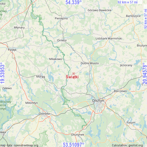
Świątki GPS coordinates[2]
53° 55' 37.344" North, 20° 14' 33.54" East
| Map corner | latitude | longitude |
|---|---|---|
| Upper-left | 54.339°, | 19.53953° |
| Center: | 53.92704°, | 20.24265° |
| Lower-right: | 53.51097°, | 20.94578° |
| Map W x H: | 92.1×92.1 km | = 57.2×57.2mi |
| max Lat: | 54.83135° ⇑6.5% North |
| Świątki: | 53.92704° |
| min Lat: | ⇓93.5% South 49.21328° |
| min Long | Świątki | max Long |
| 14.20249° | 20.24265° | 24.03723° |
| W 61.8%⇐ | ⇒38.2% E |
Elevation
Elevation of Świątki is 146 m = 479 ft, and this is 45.4 m = 149 ft below average elevation for this country.
| Max E: |
974 m = 3196 ft | 60.3% |
| Avg. | 191.4 m = 628 ft | |
| Świątki | 146 m = 479 ft | |
Min E: |
-3 m = -10 ft | 39.7% |
See also: Poland elevation on elevation.city.
Geographical zone
Świątki is located in North temperate zone (between Tropic of Cancer and the Arctic Circle). Distance of this North polar circle is 1405 km =873 mi to North.| Distance of | km | miles | from Świątki |
|---|---|---|---|
| North Pole | 4010.9 | 2492.3 | to North |
| Arctic Circle | 1405 | 873 | to North |
| Tropic Cancer | 3390.2 | 2106.6 | to South |
| Equator | 5996.1 | 3725.8 | to South |


Nearby cities:
15 places around Świątki: (largest is in red/bold)
• Barczewo
31.3 km =19.4 mi,  110°
110°
• Dobre Miasto
12.1 km =7.5 mi,  56°
56°
• Dywity
18.4 km =11.4 mi,  122°
122°
• Gietrzwałd
20.1 km =12.5 mi,  180°
180°
• Jonkowo
11.9 km =7.4 mi,  157°
157°
• Kortowo
23.5 km =14.6 mi,  143°
143°
• Lidzbark Warmiński
31.2 km =19.4 mi,  44°
44°
• Lubomino
15.5 km =9.6 mi,  359°
359°
• Miłakowo
14.5 km =9 mi,  309°
309°
• Morąg
20.8 km =12.9 mi,  266°
266°
• Olsztyn
23.2 km =14.4 mi,  134°
134°
• Orneta
22.1 km =13.7 mi,  341°
341°
• Ostróda
31.4 km =19.5 mi,  215°
215°
• Spręcowo
13.8 km =8.6 mi, 112°
• Łukta
17.1 km =10.6 mi, 217°
Sources, notices
• [Note1] Compared only with cities in Poland existing in our database
• [Src1] Map data: © OpenStreetMap contributors (CC-BY-SA)
• [Src2] Other city data from geonames.org with taken over terms of usage.
• [Src3] Geographical zone / Annual Mean Temperature by Robert A. Rohde @ Wikipedia
