Dobre Miasto geodata
Dobre Miasto (Warmia-Masuria) is a populated place; located in Poland in Europe/Warsaw (GMT+2) time zone. With population of 10,514 people, there are 431 cities with bigger population in this country. Compared to other cities in Poland, 94% of cities are located further ↓South; 63.7% of cities are located further ←West and 89.2% of cities have higher elevation than Dobre Miasto. Note1
Administrative division(s):
- Level 1: Warmia-Masuria
- Level 2: Powiat olsztyński
- Level 3: Gmina Dobre Miasto


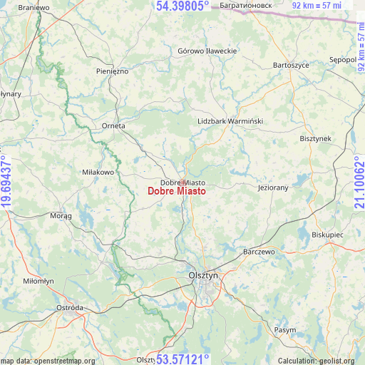
Dobre Miasto GPS coordinates[2]
53° 59' 12.048" North, 20° 23' 50.964" East
| Map corner | latitude | longitude |
|---|---|---|
| Upper-left | 54.39805°, | 19.69437° |
| Center: | 53.98668°, | 20.39749° |
| Lower-right: | 53.57121°, | 21.10062° |
| Map W x H: | 91.9×91.9 km | = 57.1×57.1mi |
| max Lat: | 54.83135° ⇑6% North |
| Dobre Miasto: | 53.98668° |
| min Lat: | ⇓94% South 49.21328° |
| min Long | Dobre Miasto | max Long |
| 14.20249° | 20.39749° | 24.03723° |
| W 63.7%⇐ | ⇒36.3% E |
Elevation
Elevation of Dobre Miasto is 78 m = 256 ft, and this is 113.4 m = 372 ft below average elevation for this country.
| Max E: |
974 m = 3196 ft | 89.2% |
| Avg. | 191.4 m = 628 ft | |
| Dobre Miasto | 78 m = 256 ft | |
Min E: |
-3 m = -10 ft | 10.8% |
See also: Poland elevation on elevation.city.
Geographical zone
Dobre Miasto is located in North temperate zone (between Tropic of Cancer and the Arctic Circle). Distance of this North polar circle is 1398.4 km =868.9 mi to North.| Distance of | km | miles | from Dobre Miasto |
|---|---|---|---|
| North Pole | 4004.3 | 2488.2 | to North |
| Arctic Circle | 1398.4 | 868.9 | to North |
| Tropic Cancer | 3396.8 | 2110.7 | to South |
| Equator | 6002.8 | 3730 | to South |


Nearby cities:
15 places around Dobre Miasto: (largest is in red/bold)
• Barczewo
25.9 km =16.1 mi,  132°
132°
• Dywity
17.4 km =10.8 mi,  162°
162°
• Gietrzwałd
28.7 km =17.8 mi,  201°
201°
• Janikowo
26.5 km =16.5 mi,  8°
8°
• Jeziorany
22.8 km =14.2 mi,  93°
93°
• Jonkowo
18.5 km =11.5 mi, 197°
• Kortowo
25.8 km =16 mi,  171°
171°
• Lidzbark Warmiński
19.5 km =12.1 mi,  37°
37°
• Lubomino
13.6 km =8.5 mi,  310°
310°
• Miłakowo
21.5 km =13.4 mi,  276°
276°
• Olsztyn
23.8 km =14.8 mi, 164°
• Orneta
22.4 km =13.9 mi, 309°
• Spręcowo
12.1 km =7.5 mi, 167°
• Łukta
28.8 km =17.9 mi,  225°
225°
• Świątki
12.1 km =7.5 mi,  236°
236°
Sources, notices
• [Note1] Compared only with cities in Poland existing in our database
• [Src1] Map data: © OpenStreetMap contributors (CC-BY-SA)
• [Src2] Other city data from geonames.org with taken over terms of usage.
• [Src3] Geographical zone / Annual Mean Temperature by Robert A. Rohde @ Wikipedia
