Barczewo geodata
Barczewo (Warmia-Masuria) is a seat of a third-order administrative division; located in Poland in Europe/Warsaw (GMT+2) time zone. With population of 7,315 people, there are 525 cities with bigger population in this country. Compared to other cities in Poland, 92.5% of cities are located further ↓South; 67.4% of cities are located further ←West and 66.4% of cities have higher elevation than Barczewo. Note1


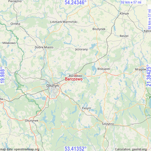
Barczewo GPS coordinates[2]
53° 49' 49.98" North, 20° 41' 28.032" East
| Map corner | latitude | longitude |
|---|---|---|
| Upper-left | 54.24346°, | 19.988° |
| Center: | 53.83055°, | 20.69112° |
| Lower-right: | 53.41352°, | 21.39425° |
| Map W x H: | 92.3×92.3 km | = 57.4×57.4mi |
| max Lat: | 54.83135° ⇑7.5% North |
| Barczewo: | 53.83055° |
| min Lat: | ⇓92.5% South 49.21328° |
| min Long | Barczewo | max Long |
| 14.20249° | 20.69112° | 24.03723° |
| W 67.4%⇐ | ⇒32.6% E |
Elevation
Elevation of Barczewo is 129 m = 423 ft, and this is 62.4 m = 205 ft below average elevation for this country.
| Max E: |
974 m = 3196 ft | 66.4% |
| Avg. | 191.4 m = 628 ft | |
| Barczewo | 129 m = 423 ft | |
Min E: |
-3 m = -10 ft | 33.6% |
See also: Poland elevation on elevation.city.
Geographical zone
Barczewo is located in North temperate zone (between Tropic of Cancer and the Arctic Circle). Distance of this North polar circle is 1415.8 km =879.7 mi to North.| Distance of | km | miles | from Barczewo |
|---|---|---|---|
| North Pole | 4021.7 | 2499 | to North |
| Arctic Circle | 1415.8 | 879.7 | to North |
| Tropic Cancer | 3379.5 | 2099.9 | to South |
| Equator | 5985.4 | 3719.2 | to South |


Nearby cities:
15 places around Barczewo: (largest is in red/bold)
• Biskupiec
17.8 km =11.1 mi,  77°
77°
• Czerwonka
16.5 km =10.3 mi,  54°
54°
• Dobre Miasto
25.9 km =16.1 mi,  312°
312°
• Dywity
14 km =8.7 mi,  273°
273°
• Dźwierzuty
22.5 km =14 mi,  128°
128°
• Jeziorany
16.5 km =10.3 mi,  12°
12°
• Jonkowo
25 km =15.5 mi, 269°
• Kolno
27.2 km =16.9 mi, 47°
• Kortowo
17.4 km =10.8 mi,  242°
242°
• Olsztyn
14.1 km =8.8 mi,  246°
246°
• Pasym
21.1 km =13.1 mi,  161°
161°
• Purda
13.6 km =8.5 mi,  175°
175°
• Sorkwity
29.5 km =18.3 mi,  86°
86°
• Spręcowo
17.5 km =10.9 mi,  288°
288°
• Stawiguda
27.1 km =16.8 mi,  224°
224°
Sources, notices
• [Note1] Compared only with cities in Poland existing in our database
• [Src1] Map data: © OpenStreetMap contributors (CC-BY-SA)
• [Src2] Other city data from geonames.org with taken over terms of usage.
• [Src3] Geographical zone / Annual Mean Temperature by Robert A. Rohde @ Wikipedia
