Spręcowo geodata
Spręcowo (Warmia-Masuria) is a populated place; located in Poland in Europe/Warsaw (GMT+2) time zone. With population of 531 people, there are 3450 cities with bigger population in this country. Compared to other cities in Poland, 93% of cities are located further ↓South; 64.2% of cities are located further ←West and 68.9% of cities have higher elevation than Spręcowo. Note1
Administrative division(s):
- Level 1: Warmia-Masuria
- Level 2: Powiat olsztyński
- Level 3: Gmina Dywity


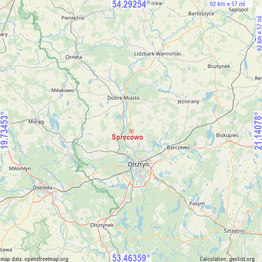
Spręcowo GPS coordinates[2]
53° 52' 48.432" North, 20° 26' 15.54" East
| Map corner | latitude | longitude |
|---|---|---|
| Upper-left | 54.29254°, | 19.73453° |
| Center: | 53.88012°, | 20.43765° |
| Lower-right: | 53.46359°, | 21.14078° |
| Map W x H: | 92.2×92.2 km | = 57.3×57.3mi |
| max Lat: | 54.83135° ⇑7% North |
| Spręcowo: | 53.88012° |
| min Lat: | ⇓93% South 49.21328° |
| min Long | Spręcowo | max Long |
| 14.20249° | 20.43765° | 24.03723° |
| W 64.2%⇐ | ⇒35.8% E |
Elevation
Elevation of Spręcowo is 123 m = 404 ft, and this is 68.4 m = 224 ft below average elevation for this country.
| Max E: |
974 m = 3196 ft | 68.9% |
| Avg. | 191.4 m = 628 ft | |
| Spręcowo | 123 m = 404 ft | |
Min E: |
-3 m = -10 ft | 31.1% |
See also: Poland elevation on elevation.city.
Geographical zone
Spręcowo is located in North temperate zone (between Tropic of Cancer and the Arctic Circle). Distance of this North polar circle is 1410.3 km =876.3 mi to North.| Distance of | km | miles | from Spręcowo |
|---|---|---|---|
| North Pole | 4016.2 | 2495.6 | to North |
| Arctic Circle | 1410.3 | 876.3 | to North |
| Tropic Cancer | 3385 | 2103.3 | to South |
| Equator | 5990.9 | 3722.6 | to South |


Nearby cities:
15 places around Spręcowo: (largest is in red/bold)
• Barczewo
17.5 km =10.9 mi,  108°
108°
• Dobre Miasto
12.1 km =7.5 mi,  347°
347°
• Dywity
5.4 km =3.4 mi,  150°
150°
• Gietrzwałd
19.9 km =12.4 mi,  221°
221°
• Jeziorany
22.8 km =14.2 mi,  62°
62°
• Jonkowo
10.1 km =6.3 mi,  235°
235°
• Kortowo
13.7 km =8.5 mi,  174°
174°
• Lidzbark Warmiński
28.9 km =18 mi,  18°
18°
• Lubomino
24.5 km =15.2 mi,  328°
328°
• Miłakowo
27.9 km =17.3 mi,  300°
300°
• Olsztyn
11.7 km =7.3 mi,  161°
161°
• Purda
26 km =16.2 mi,  137°
137°
• Stawiguda
24.9 km =15.5 mi,  185°
185°
• Łukta
24.7 km =15.3 mi,  250°
250°
• Świątki
13.8 km =8.6 mi,  292°
292°
Sources, notices
• [Note1] Compared only with cities in Poland existing in our database
• [Src1] Map data: © OpenStreetMap contributors (CC-BY-SA)
• [Src2] Other city data from geonames.org with taken over terms of usage.
• [Src3] Geographical zone / Annual Mean Temperature by Robert A. Rohde @ Wikipedia
