Purda geodata
Purda (Warmia-Masuria) is a populated place; located in Poland in Europe/Warsaw (GMT+2) time zone. With population of 1,140 people, there are 2265 cities with bigger population in this country. Compared to other cities in Poland, 91.5% of cities are located further ↓South; 67.7% of cities are located further ←West and 62.4% of cities have higher elevation than Purda. Note1


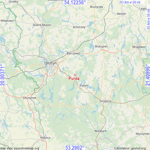
Purda GPS coordinates[2]
53° 42' 30.384" North, 20° 42' 24.588" East
| Map corner | latitude | longitude |
|---|---|---|
| Upper-left | 54.12256°, | 20.00371° |
| Center: | 53.70844°, | 20.70683° |
| Lower-right: | 53.2902°, | 21.40996° |
| Map W x H: | 92.5×92.5 km | = 57.5×57.5mi |
| max Lat: | 54.83135° ⇑8.5% North |
| Purda: | 53.70844° |
| min Lat: | ⇓91.5% South 49.21328° |
| min Long | Purda | max Long |
| 14.20249° | 20.70683° | 24.03723° |
| W 67.7%⇐ | ⇒32.3% E |
Elevation
Elevation of Purda is 141 m = 463 ft, and this is 50.4 m = 165 ft below average elevation for this country.
| Max E: |
974 m = 3196 ft | 62.4% |
| Avg. | 191.4 m = 628 ft | |
| Purda | 141 m = 463 ft | |
Min E: |
-3 m = -10 ft | 37.6% |
See also: Poland elevation on elevation.city.
Geographical zone
Purda is located in North temperate zone (between Tropic of Cancer and the Arctic Circle). Distance of this North polar circle is 1429.4 km =888.2 mi to North.| Distance of | km | miles | from Purda |
|---|---|---|---|
| North Pole | 4035.2 | 2507.4 | to North |
| Arctic Circle | 1429.4 | 888.2 | to North |
| Tropic Cancer | 3365.9 | 2091.5 | to South |
| Equator | 5971.8 | 3710.7 | to South |


Nearby cities:
15 places around Purda: (largest is in red/bold)
• Barczewo
13.6 km =8.5 mi,  355°
355°
• Biskupiec
23.9 km =14.9 mi,  43°
43°
• Czerwonka
26.3 km =16.3 mi,  28°
28°
• Dywity
20.8 km =12.9 mi,  313°
313°
• Dźwierzuty
16.7 km =10.4 mi,  91°
91°
• Jabłonka
25.5 km =15.8 mi,  202°
202°
• Jedwabno
19.9 km =12.4 mi,  176°
176°
• Jeziorany
29.8 km =18.5 mi,  4°
4°
• Jonkowo
29.2 km =18.1 mi,  297°
297°
• Kortowo
17.4 km =10.8 mi,  288°
288°
• Olsztyn
16.1 km =10 mi, 299°
• Pasym
8.5 km =5.3 mi,  138°
138°
• Spręcowo
26 km =16.2 mi,  317°
317°
• Stawiguda
21 km =13 mi,  254°
254°
• Szczytno
24.6 km =15.3 mi,  131°
131°
Sources, notices
• [Note1] Compared only with cities in Poland existing in our database
• [Src1] Map data: © OpenStreetMap contributors (CC-BY-SA)
• [Src2] Other city data from geonames.org with taken over terms of usage.
• [Src3] Geographical zone / Annual Mean Temperature by Robert A. Rohde @ Wikipedia
