Jeziorany geodata
Jeziorany (Warmia-Masuria) is a seat of a third-order administrative division; located in Poland in Europe/Warsaw (GMT+2) time zone. With population of 3,382 people, there are 944 cities with bigger population in this country. Compared to other cities in Poland, 93.9% of cities are located further ↓South; 68.4% of cities are located further ←West and 62.1% of cities have higher elevation than Jeziorany. Note1


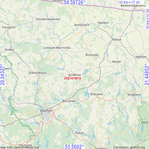
Jeziorany GPS coordinates[2]
53° 58' 32.808" North, 20° 44' 47.004" East
| Map corner | latitude | longitude |
|---|---|---|
| Upper-left | 54.38726°, | 20.04327° |
| Center: | 53.97578°, | 20.74639° |
| Lower-right: | 53.5602°, | 21.44952° |
| Map W x H: | 92×92 km | = 57.2×57.2mi |
| max Lat: | 54.83135° ⇑6.1% North |
| Jeziorany: | 53.97578° |
| min Lat: | ⇓93.9% South 49.21328° |
| min Long | Jeziorany | max Long |
| 14.20249° | 20.74639° | 24.03723° |
| W 68.4%⇐ | ⇒31.6% E |
Elevation
Elevation of Jeziorany is 142 m = 466 ft, and this is 49.4 m = 162 ft below average elevation for this country.
| Max E: |
974 m = 3196 ft | 62.1% |
| Avg. | 191.4 m = 628 ft | |
| Jeziorany | 142 m = 466 ft | |
Min E: |
-3 m = -10 ft | 37.9% |
See also: Poland elevation on elevation.city.
Geographical zone
Jeziorany is located in North temperate zone (between Tropic of Cancer and the Arctic Circle). Distance of this North polar circle is 1399.6 km =869.7 mi to North.| Distance of | km | miles | from Jeziorany |
|---|---|---|---|
| North Pole | 4005.5 | 2488.9 | to North |
| Arctic Circle | 1399.6 | 869.7 | to North |
| Tropic Cancer | 3395.6 | 2109.9 | to South |
| Equator | 6001.5 | 3729.2 | to South |


Nearby cities:
15 places around Jeziorany: (largest is in red/bold)
• Barczewo
16.5 km =10.3 mi,  192°
192°
• Bartoszyce
31.1 km =19.3 mi,  7°
7°
• Biskupiec
18.5 km =11.5 mi,  131°
131°
• Bisztynek
15.9 km =9.9 mi,  39°
39°
• Czerwonka
11.9 km =7.4 mi,  123°
123°
• Dobre Miasto
22.8 km =14.2 mi,  273°
273°
• Dywity
23.3 km =14.5 mi,  228°
228°
• Kolno
16.4 km =10.2 mi,  81°
81°
• Kortowo
30.9 km =19.2 mi,  218°
218°
• Lidzbark Warmiński
19.9 km =12.4 mi,  326°
326°
• Olsztyn
27.3 km =17 mi, 217°
• Purda
29.8 km =18.5 mi,  184°
184°
• Reszel
27.4 km =17 mi,  72°
72°
• Sorkwity
29.6 km =18.4 mi, 119°
• Spręcowo
22.8 km =14.2 mi,  242°
242°
Sources, notices
• [Note1] Compared only with cities in Poland existing in our database
• [Src1] Map data: © OpenStreetMap contributors (CC-BY-SA)
• [Src2] Other city data from geonames.org with taken over terms of usage.
• [Src3] Geographical zone / Annual Mean Temperature by Robert A. Rohde @ Wikipedia
