Czerwonka geodata
Czerwonka (Warmia-Masuria) is a populated place; located in Poland in Europe/Warsaw (GMT+2) time zone. With population of 1,090 people, there are 2369 cities with bigger population in this country. Compared to other cities in Poland, 93.3% of cities are located further ↓South; 70.7% of cities are located further ←West and 61.1% of cities have higher elevation than Czerwonka. Note1


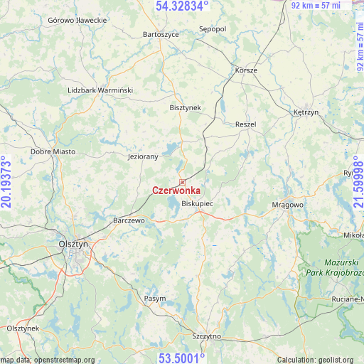
Czerwonka GPS coordinates[2]
53° 54' 58.572" North, 20° 53' 48.66" East
| Map corner | latitude | longitude |
|---|---|---|
| Upper-left | 54.32834°, | 20.19373° |
| Center: | 53.91627°, | 20.89685° |
| Lower-right: | 53.5001°, | 21.59998° |
| Map W x H: | 92.1×92.1 km | = 57.2×57.2mi |
| max Lat: | 54.83135° ⇑6.7% North |
| Czerwonka: | 53.91627° |
| min Lat: | ⇓93.3% South 49.21328° |
| min Long | Czerwonka | max Long |
| 14.20249° | 20.89685° | 24.03723° |
| W 70.7%⇐ | ⇒29.3% E |
Elevation
Elevation of Czerwonka is 144 m = 472 ft, and this is 47.4 m = 156 ft below average elevation for this country.
| Max E: |
974 m = 3196 ft | 61.1% |
| Avg. | 191.4 m = 628 ft | |
| Czerwonka | 144 m = 472 ft | |
Min E: |
-3 m = -10 ft | 38.9% |
See also: Poland elevation on elevation.city.
Geographical zone
Czerwonka is located in North temperate zone (between Tropic of Cancer and the Arctic Circle). Distance of this North polar circle is 1406.2 km =873.8 mi to North.| Distance of | km | miles | from Czerwonka |
|---|---|---|---|
| North Pole | 4012.1 | 2493 | to North |
| Arctic Circle | 1406.2 | 873.8 | to North |
| Tropic Cancer | 3389 | 2105.8 | to South |
| Equator | 5994.9 | 3725.1 | to South |


Nearby cities:
15 places around Czerwonka: (largest is in red/bold)
• Barczewo
16.5 km =10.3 mi,  234°
234°
• Biskupiec
7 km =4.3 mi,  145°
145°
• Bisztynek
18.9 km =11.7 mi,  1°
1°
• Dywity
28.8 km =17.9 mi,  252°
252°
• Dźwierzuty
23.9 km =14.9 mi,  169°
169°
• Jeziorany
11.9 km =7.4 mi,  303°
303°
• Kolno
11 km =6.8 mi,  35°
35°
• Lidzbark Warmiński
31.2 km =19.4 mi,  318°
318°
• Mrągowo
27.4 km =17 mi,  102°
102°
• Olsztyn
30.5 km =19 mi,  240°
240°
• Pasym
30.3 km =18.8 mi,  193°
193°
• Purda
26.3 km =16.3 mi,  208°
208°
• Reszel
22.1 km =13.7 mi,  47°
47°
• Sorkwity
17.8 km =11.1 mi,  116°
116°
• Spręcowo
30.4 km =18.9 mi,  262°
262°
Sources, notices
• [Note1] Compared only with cities in Poland existing in our database
• [Src1] Map data: © OpenStreetMap contributors (CC-BY-SA)
• [Src2] Other city data from geonames.org with taken over terms of usage.
• [Src3] Geographical zone / Annual Mean Temperature by Robert A. Rohde @ Wikipedia
