Biskupiec geodata
Biskupiec (Warmia-Masuria) is a seat of a third-order administrative division; located in Poland in Europe/Warsaw (GMT+2) time zone. With population of 10,340 people, there are 434 cities with bigger population in this country. Compared to other cities in Poland, 92.9% of cities are located further ↓South; 71.8% of cities are located further ←West and 57.6% of cities have higher elevation than Biskupiec. Note1


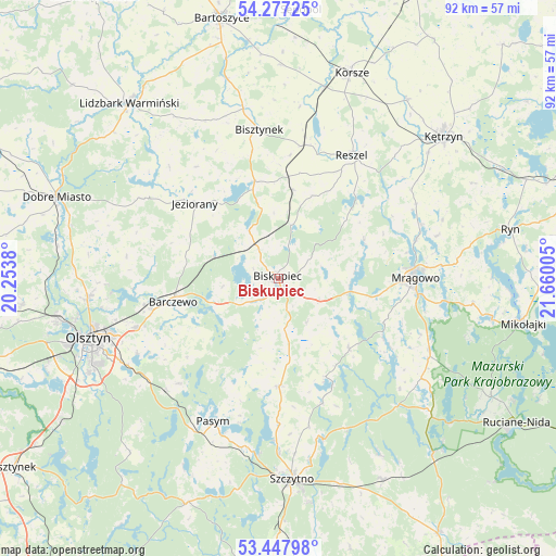
Biskupiec GPS coordinates[2]
53° 51' 52.812" North, 20° 57' 24.912" East
| Map corner | latitude | longitude |
|---|---|---|
| Upper-left | 54.27725°, | 20.2538° |
| Center: | 53.86467°, | 20.95692° |
| Lower-right: | 53.44798°, | 21.66005° |
| Map W x H: | 92.2×92.2 km | = 57.3×57.3mi |
| max Lat: | 54.83135° ⇑7.1% North |
| Biskupiec: | 53.86467° |
| min Lat: | ⇓92.9% South 49.21328° |
| min Long | Biskupiec | max Long |
| 14.20249° | 20.95692° | 24.03723° |
| W 71.8%⇐ | ⇒28.2% E |
Elevation
Elevation of Biskupiec is 152 m = 499 ft, and this is 39.4 m = 129 ft below average elevation for this country.
| Max E: |
974 m = 3196 ft | 57.6% |
| Avg. | 191.4 m = 628 ft | |
| Biskupiec | 152 m = 499 ft | |
Min E: |
-3 m = -10 ft | 42.4% |
See also: Poland elevation on elevation.city.
Geographical zone
Biskupiec is located in North temperate zone (between Tropic of Cancer and the Arctic Circle). Distance of this North polar circle is 1412 km =877.4 mi to North.| Distance of | km | miles | from Biskupiec |
|---|---|---|---|
| North Pole | 4017.9 | 2496.6 | to North |
| Arctic Circle | 1412 | 877.4 | to North |
| Tropic Cancer | 3383.3 | 2102.3 | to South |
| Equator | 5989.2 | 3721.5 | to South |


Nearby cities:
15 places around Biskupiec: (largest is in red/bold)
• Baranowo
32.4 km =20.1 mi,  97°
97°
• Barczewo
17.8 km =11.1 mi,  257°
257°
• Bisztynek
24.9 km =15.5 mi,  351°
351°
• Czerwonka
7 km =4.3 mi,  325°
325°
• Dywity
31.5 km =19.6 mi, 264°
• Dźwierzuty
17.8 km =11.1 mi,  179°
179°
• Jeziorany
18.5 km =11.5 mi,  311°
311°
• Kolno
14.9 km =9.3 mi,  9°
9°
• Mrągowo
22.8 km =14.2 mi,  90°
90°
• Olsztyn
31.8 km =19.8 mi,  252°
252°
• Pasym
26.1 km =16.2 mi,  204°
204°
• Piecki
27.8 km =17.3 mi,  115°
115°
• Purda
23.9 km =14.9 mi,  223°
223°
• Reszel
24.1 km =15 mi,  30°
30°
• Sorkwity
12.2 km =7.6 mi, 99°
Sources, notices
• [Note1] Compared only with cities in Poland existing in our database
• [Src1] Map data: © OpenStreetMap contributors (CC-BY-SA)
• [Src2] Other city data from geonames.org with taken over terms of usage.
• [Src3] Geographical zone / Annual Mean Temperature by Robert A. Rohde @ Wikipedia
