Zwoleń geodata
Zwoleń (Mazovia) is a seat of a second-order administrative division; located in Poland in Europe/Warsaw (GMT+2) time zone. With population of 8,048 people, there are 507 cities with bigger population in this country. Compared to other cities in Poland, 54.1% of cities are located further ↓South; 80.1% of cities are located further ←West and 57.1% of cities have higher elevation than Zwoleń. Note1


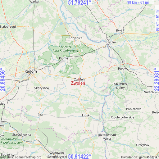
Zwoleń GPS coordinates[2]
51° 21' 19.512" North, 21° 35' 15.648" East
| Map corner | latitude | longitude |
|---|---|---|
| Upper-left | 51.79241°, | 20.88456° |
| Center: | 51.35542°, | 21.58768° |
| Lower-right: | 50.91422°, | 22.29081° |
| Map W x H: | 97.6×97.6 km | = 60.6×60.6mi |
| max Lat: | 54.83135° ⇑45.9% North |
| Zwoleń: | 51.35542° |
| min Lat: | ⇓54.1% South 49.21328° |
| min Long | Zwoleń | max Long |
| 14.20249° | 21.58768° | 24.03723° |
| W 80.1%⇐ | ⇒19.9% E |
Elevation
Elevation of Zwoleń is 153 m = 502 ft, and this is 38.4 m = 126 ft below average elevation for this country.
| Max E: |
974 m = 3196 ft | 57.1% |
| Avg. | 191.4 m = 628 ft | |
| Zwoleń | 153 m = 502 ft | |
Min E: |
-3 m = -10 ft | 42.9% |
See also: Poland elevation on elevation.city.
Geographical zone
Zwoleń is located in North temperate zone (between Tropic of Cancer and the Arctic Circle). Distance of this North polar circle is 1691 km =1050.7 mi to North.| Distance of | km | miles | from Zwoleń |
|---|---|---|---|
| North Pole | 4296.9 | 2670 | to North |
| Arctic Circle | 1691 | 1050.7 | to North |
| Tropic Cancer | 3104.3 | 1928.9 | to South |
| Equator | 5710.2 | 3548.2 | to South |


Nearby cities:
15 places around Zwoleń: (largest is in red/bold)
• Chotcza
18.3 km =11.4 mi,  134°
134°
• Ciepielów
11.9 km =7.4 mi,  184°
184°
• Garbatka-Letnisko
14.3 km =8.9 mi,  6°
6°
• Gniewoszów
20.4 km =12.7 mi,  49°
49°
• Gózd
14.7 km =9.1 mi,  279°
279°
• Janowiec
21.3 km =13.2 mi,  99°
99°
• Jedlnia-Letnisko
19.4 km =12.1 mi,  295°
295°
• Kazanów
12.2 km =7.6 mi,  223°
223°
• Lipsko
22.2 km =13.8 mi,  168°
168°
• Pionki
16.5 km =10.3 mi,  324°
324°
• Policzna
11.4 km =7.1 mi, 13°
• Przyłęk
12.3 km =7.6 mi,  115°
115°
• Tczów
10.3 km =6.4 mi,  251°
251°
• Wielgie
14.2 km =8.8 mi,  206°
206°
• Łagów
11.4 km =7.1 mi,  83°
83°
Sources, notices
• [Note1] Compared only with cities in Poland existing in our database
• [Src1] Map data: © OpenStreetMap contributors (CC-BY-SA)
• [Src2] Other city data from geonames.org with taken over terms of usage.
• [Src3] Geographical zone / Annual Mean Temperature by Robert A. Rohde @ Wikipedia
