Łagów geodata
Łagów (Mazovia) is a populated place; located in Poland in Europe/Warsaw (GMT+2) time zone. With population of 506 people, there are 3526 cities with bigger population in this country. Compared to other cities in Poland, 54.3% of cities are located further ↓South; 81.8% of cities are located further ←West and 51.6% of cities have higher elevation than Łagów. Note1


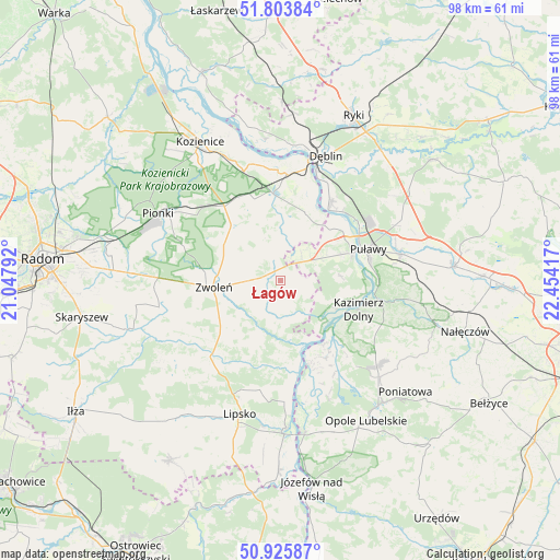
Łagów GPS coordinates[2]
51° 22' 1.056" North, 21° 45' 3.744" East
| Map corner | latitude | longitude |
|---|---|---|
| Upper-left | 51.80384°, | 21.04792° |
| Center: | 51.36696°, | 21.75104° |
| Lower-right: | 50.92587°, | 22.45417° |
| Map W x H: | 97.6×97.6 km | = 60.6×60.6mi |
| max Lat: | 54.83135° ⇑45.7% North |
| Łagów: | 51.36696° |
| min Lat: | ⇓54.3% South 49.21328° |
| min Long | Łagów | max Long |
| 14.20249° | 21.75104° | 24.03723° |
| W 81.8%⇐ | ⇒18.2% E |
Elevation
Elevation of Łagów is 168 m = 551 ft, and this is 23.4 m = 77 ft below average elevation for this country.
| Max E: |
974 m = 3196 ft | 51.6% |
| Avg. | 191.4 m = 628 ft | |
| Łagów | 168 m = 551 ft | |
Min E: |
-3 m = -10 ft | 48.4% |
See also: Poland elevation on elevation.city.
Geographical zone
Łagów is located in North temperate zone (between Tropic of Cancer and the Arctic Circle). Distance of this North polar circle is 1689.7 km =1049.9 mi to North.| Distance of | km | miles | from Łagów |
|---|---|---|---|
| North Pole | 4295.6 | 2669.2 | to North |
| Arctic Circle | 1689.7 | 1049.9 | to North |
| Tropic Cancer | 3105.6 | 1929.7 | to South |
| Equator | 5711.5 | 3549 | to South |


Nearby cities:
15 places around Łagów: (largest is in red/bold)
• Chotcza
14.2 km =8.8 mi,  172°
172°
• Ciepielów
18 km =11.2 mi,  222°
222°
• Garbatka-Letnisko
16.2 km =10.1 mi,  323°
323°
• Gniewoszów
12.7 km =7.9 mi,  19°
19°
• Janowiec
10.8 km =6.7 mi,  116°
116°
• Karczmiska
22.1 km =13.7 mi,  133°
133°
• Kazanów
22.2 km =13.8 mi,  242°
242°
• Kazimierz Dolny
15.1 km =9.4 mi,  110°
110°
• Końskowola
21.4 km =13.3 mi,  77°
77°
• Policzna
13.1 km =8.1 mi, 318°
• Przyłęk
6.5 km =4 mi,  182°
182°
• Puławy
16.1 km =10 mi,  70°
70°
• Tczów
21.6 km =13.4 mi,  257°
257°
• Wilków
14.6 km =9.1 mi,  142°
142°
• Zwoleń
11.4 km =7.1 mi, 263°
Sources, notices
• [Note1] Compared only with cities in Poland existing in our database
• [Src1] Map data: © OpenStreetMap contributors (CC-BY-SA)
• [Src2] Other city data from geonames.org with taken over terms of usage.
• [Src3] Geographical zone / Annual Mean Temperature by Robert A. Rohde @ Wikipedia
