Seryshevo geodata
Seryshevo (Amur Oblast) is a populated place; located in Russia in Asia/Yakutsk (GMT+9) time zone. With population of 11,794 people, there are 1301 cities with bigger population in this country. Compared to other cities in Russia, 74.6% of cities are located further ↑North; 93.9% of cities are located further ←West and 62.1% of cities have lower elevation than Seryshevo. Note1


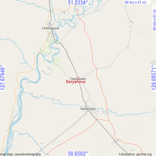
Seryshevo GPS coordinates[2]
51° 5' 38.076" North, 128° 22' 57.288" East
| Map corner | latitude | longitude |
|---|---|---|
| Upper-left | 51.5334°, | 127.67946° |
| Center: | 51.09391°, | 128.38258° |
| Lower-right: | 50.6502°, | 129.08571° |
| Map W x H: | 98.2×98.2 km | = 61×61mi |
| max Lat: | 73.50819° ⇑74.6% North |
| Seryshevo: | 51.09391° |
| min Lat: | ⇓25.4% South 41.28413° |
| min Long | Seryshevo | max Long |
| -179.12198° | 128.38258° | 179.35046° |
| W 93.9%⇐ | ⇒6.1% E |
Elevation
Elevation of Seryshevo is 174 m = 571 ft, and this is 28.6 m = 94 ft below average elevation for this country.
| Max E: |
2518 m = 8261 ft | 37.9% |
| Avg. | 202.6 m = 665 ft | |
| Seryshevo | 174 m = 571 ft | |
Min E: |
-28 m = -92 ft | 62.1% |
See also: Russia elevation on elevation.city.
Geographical zone
Seryshevo is located in North temperate zone (between Tropic of Cancer and the Arctic Circle). Distance of this North polar circle is 1720.1 km =1068.8 mi to North.| Distance of | km | miles | from Seryshevo |
|---|---|---|---|
| North Pole | 4326 | 2688.1 | to North |
| Arctic Circle | 1720.1 | 1068.8 | to North |
| Tropic Cancer | 3075.2 | 1910.8 | to South |
| Equator | 5681.1 | 3530.1 | to South |


Nearby cities:
15 places around Seryshevo: (largest is in red/bold)
• Belogorsk
20.8 km =12.9 mi,  161°
161°
• Blagoveshchensk
108.2 km =67.2 mi,  213°
213°
• Konstantinovka
166.4 km =103.4 mi,  189°
189°
• Novoraychikhinsk
168.9 km =104.9 mi,  149°
149°
• Poyarkovo
164.3 km =102.1 mi,  173°
173°
• Raychikhinsk
162.2 km =100.8 mi, 153°
• Romny
76 km =47.2 mi,  123°
123°
• Shimanovsk
112.5 km =69.9 mi,  334°
334°
• Srednebelaya
55 km =34.2 mi, 208°
• Svobodnyy
35.5 km =22.1 mi, 331°
• Talakan
161.7 km =100.5 mi, 124°
• Tambovka
112.9 km =70.2 mi, 191°
• Tsiolkovskiy
77.1 km =47.9 mi,  346°
346°
• Yekaterinoslavka
95.1 km =59.1 mi, 147°
• Zavitinsk
132.4 km =82.3 mi, 145°
Sources, notices
• [Note1] Compared only with cities in Russia existing in our database
• [Src1] Map data: © OpenStreetMap contributors (CC-BY-SA)
• [Src2] Other city data from geonames.org with taken over terms of usage.
• [Src3] Geographical zone / Annual Mean Temperature by Robert A. Rohde @ Wikipedia
