Belogorsk geodata
Belogorsk (Amur Oblast) is a populated place; located in Russia in Asia/Yakutsk (GMT+9) time zone. With population of 67,911 people, there are 300 cities with bigger population in this country. Compared to other cities in Russia, 75.3% of cities are located further ↑North; 93.9% of cities are located further ←West and 60.3% of cities have lower elevation than Belogorsk. Note1


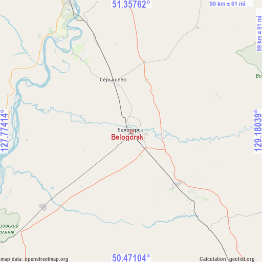
Belogorsk GPS coordinates[2]
50° 54' 59.184" North, 128° 28' 38.136" East
| Map corner | latitude | longitude |
|---|---|---|
| Upper-left | 51.35762°, | 127.77414° |
| Center: | 50.91644°, | 128.47726° |
| Lower-right: | 50.47104°, | 129.18039° |
| Map W x H: | 98.6×98.6 km | = 61.3×61.3mi |
| max Lat: | 73.50819° ⇑75.3% North |
| Belogorsk: | 50.91644° |
| min Lat: | ⇓24.7% South 41.28413° |
| min Long | Belogorsk | max Long |
| -179.12198° | 128.47726° | 179.35046° |
| W 93.9%⇐ | ⇒6.1% E |
Elevation
Elevation of Belogorsk is 169 m = 554 ft, and this is 33.6 m = 110 ft below average elevation for this country.
| Max E: |
2518 m = 8261 ft | 39.7% |
| Avg. | 202.6 m = 665 ft | |
| Belogorsk | 169 m = 554 ft | |
Min E: |
-28 m = -92 ft | 60.3% |
See also: Belogorsk elevation on elevation.city.
Geographical zone
Belogorsk is located in North temperate zone (between Tropic of Cancer and the Arctic Circle). Distance of this North polar circle is 1739.8 km =1081.1 mi to North.| Distance of | km | miles | from Belogorsk |
|---|---|---|---|
| North Pole | 4345.7 | 2700.3 | to North |
| Arctic Circle | 1739.8 | 1081.1 | to North |
| Tropic Cancer | 3055.5 | 1898.6 | to South |
| Equator | 5661.4 | 3517.8 | to South |


Nearby cities:
15 places around Belogorsk: (largest is in red/bold)
• Blagoveshchensk
96.9 km =60.2 mi,  223°
223°
• Konstantinovka
148.4 km =92.2 mi,  193°
193°
• Poyarkovo
143.9 km =89.4 mi,  175°
175°
• Raychikhinsk
141.7 km =88 mi,  152°
152°
• Romny
61.2 km =38 mi,  110°
110°
• Seryshevo
20.8 km =12.9 mi,  341°
341°
• Shimanovsk
133.2 km =82.8 mi, 335°
• Shirokiy
148.4 km =92.2 mi, 150°
• Srednebelaya
43.6 km =27.1 mi,  228°
228°
• Svobodnyy
56.1 km =34.9 mi, 335°
• Talakan
145.7 km =90.5 mi,  119°
119°
• Tambovka
95.5 km =59.3 mi,  198°
198°
• Tsiolkovskiy
97.9 km =60.8 mi,  345°
345°
• Yekaterinoslavka
75.1 km =46.7 mi,  143°
143°
• Zavitinsk
112.5 km =69.9 mi, 142°
Sources, notices
• [Note1] Compared only with cities in Russia existing in our database
• [Src1] Map data: © OpenStreetMap contributors (CC-BY-SA)
• [Src2] Other city data from geonames.org with taken over terms of usage.
• [Src3] Geographical zone / Annual Mean Temperature by Robert A. Rohde @ Wikipedia
