Romny geodata
Romny (Amur Oblast) is a populated place; located in Russia in Asia/Yakutsk (GMT+9) time zone. With population of 3,413 people, there are 3461 cities with bigger population in this country. Compared to other cities in Russia, 75.9% of cities are located further ↑North; 94% of cities are located further ←West and 77.8% of cities have lower elevation than Romny. Note1


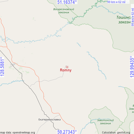
Romny GPS coordinates[2]
50° 43' 14.52" North, 129° 17' 28.392" East
| Map corner | latitude | longitude |
|---|---|---|
| Upper-left | 51.16374°, | 128.5881° |
| Center: | 50.7207°, | 129.29122° |
| Lower-right: | 50.27343°, | 129.99435° |
| Map W x H: | 99×99 km | = 61.5×61.5mi |
| max Lat: | 73.50819° ⇑75.9% North |
| Romny: | 50.7207° |
| min Lat: | ⇓24.1% South 41.28413° |
| min Long | Romny | max Long |
| -179.12198° | 129.29122° | 179.35046° |
| W 94%⇐ | ⇒6% E |
Elevation
Elevation of Romny is 232 m = 761 ft, and this is 29.4 m = 96 ft above average elevation for this country.
| Max E: |
2518 m = 8261 ft | 22.2% |
| Romny | 232 m 761 ft | |
| Avg. | 202.6 m = 665 ft | |
Min E: |
-28 m = -92 ft | 77.8% |
See also: Russia elevation on elevation.city.
Geographical zone
Romny is located in North temperate zone (between Tropic of Cancer and the Arctic Circle). Distance of this North polar circle is 1761.6 km =1094.6 mi to North.| Distance of | km | miles | from Romny |
|---|---|---|---|
| North Pole | 4367.4 | 2713.8 | to North |
| Arctic Circle | 1761.6 | 1094.6 | to North |
| Tropic Cancer | 3033.7 | 1885.1 | to South |
| Equator | 5639.6 | 3504.3 | to South |


Nearby cities:
15 places around Romny: (largest is in red/bold)
• Belogorsk
61.2 km =38 mi,  290°
290°
• Blagoveshchensk
133.2 km =82.8 mi,  248°
248°
• Bureya
107.6 km =66.9 mi,  159°
159°
• Novobureyskiy
110.8 km =68.8 mi, 158°
• Novoraychikhinsk
106.3 km =66.1 mi,  168°
168°
• Poyarkovo
129.8 km =80.7 mi,  200°
200°
• Raychikhinsk
103.8 km =64.5 mi,  175°
175°
• Seryshevo
76 km =47.2 mi,  303°
303°
• Shirokiy
108.2 km =67.2 mi, 171°
• Srednebelaya
90.6 km =56.3 mi,  265°
265°
• Svobodnyy
108.4 km =67.4 mi,  312°
312°
• Talakan
85.7 km =53.3 mi,  126°
126°
• Tambovka
111.4 km =69.2 mi,  231°
231°
• Yekaterinoslavka
40.7 km =25.3 mi, 198°
• Zavitinsk
68.6 km =42.6 mi, 171°
Sources, notices
• [Note1] Compared only with cities in Russia existing in our database
• [Src1] Map data: © OpenStreetMap contributors (CC-BY-SA)
• [Src2] Other city data from geonames.org with taken over terms of usage.
• [Src3] Geographical zone / Annual Mean Temperature by Robert A. Rohde @ Wikipedia
