Blagoveshchensk geodata
Blagoveshchensk (Amur Oblast) is a seat of a first-order administrative division; located in Russia in Asia/Yakutsk (GMT+9) time zone. With population of 221,296 people, there are 89 cities with bigger population in this country. Compared to other cities in Russia, 77.4% of cities are located further ↑North; 93.7% of cities are located further ←West and 56.6% of cities have higher elevation than Blagoveshchensk. Note1


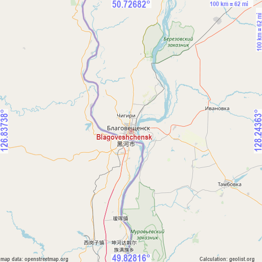
Blagoveshchensk GPS coordinates[2]
50° 16' 46.596" North, 127° 32' 25.8" East
| Map corner | latitude | longitude |
|---|---|---|
| Upper-left | 50.72682°, | 126.83738° |
| Center: | 50.27961°, | 127.5405° |
| Lower-right: | 49.82816°, | 128.24363° |
| Map W x H: | 99.9×99.9 km | = 62.1×62.1mi |
| max Lat: | 73.50819° ⇑77.4% North |
| Blagoveshchensk: | 50.27961° |
| min Lat: | ⇓22.6% South 41.28413° |
| min Long | Blagoveshchensk | max Long |
| -179.12198° | 127.5405° | 179.35046° |
| W 93.7%⇐ | ⇒6.3% E |
Elevation
Elevation of Blagoveshchensk is 131 m = 430 ft, and this is 71.6 m = 235 ft below average elevation for this country.
| Max E: |
2518 m = 8261 ft | 56.6% |
| Avg. | 202.6 m = 665 ft | |
| Blagoveshchensk | 131 m = 430 ft | |
Min E: |
-28 m = -92 ft | 43.4% |
See also: Blagoveshchensk elevation on elevation.city.
Geographical zone
Blagoveshchensk is located in North temperate zone (between Tropic of Cancer and the Arctic Circle). Distance of this North polar circle is 1810.6 km =1125.1 mi to North.| Distance of | km | miles | from Blagoveshchensk |
|---|---|---|---|
| North Pole | 4416.5 | 2744.3 | to North |
| Arctic Circle | 1810.6 | 1125.1 | to North |
| Tropic Cancer | 2984.6 | 1854.5 | to South |
| Equator | 5590.6 | 3473.8 | to South |


Nearby cities:
15 places around Blagoveshchensk: (largest is in red/bold)
• Belogorsk
96.9 km =60.2 mi,  43°
43°
• Bureya
170.4 km =105.9 mi,  107°
107°
• Konstantinovka
80.2 km =49.8 mi,  156°
156°
• Novoraychikhinsk
156.4 km =97.2 mi, 110°
• Poyarkovo
107.7 km =66.9 mi,  132°
132°
• Raychikhinsk
144.2 km =89.6 mi, 112°
• Romny
133.2 km =82.8 mi,  68°
68°
• Seryshevo
108.2 km =67.2 mi,  33°
33°
• Shirokiy
152.8 km =94.9 mi, 112°
• Srednebelaya
53.6 km =33.3 mi, 38°
• Svobodnyy
128.9 km =80.1 mi,  19°
19°
• Tambovka
41.9 km =26 mi,  118°
118°
• Tsiolkovskiy
170.2 km =105.8 mi,  13°
13°
• Yekaterinoslavka
111.9 km =69.5 mi,  84°
84°
• Zavitinsk
136.6 km =84.9 mi,  97°
97°
In other languages:
- In Spanish: Blagovéshchensk
- In France: Blagovechtchensk
- In German: Blagoweschtschensk
- In Italian: Blagoveščensk, Blagoveshchensk
- In Russian: Благовещенск
- In Chinese: 海兰泡
Sources, notices
• [Note1] Compared only with cities in Russia existing in our database
• [Src1] Map data: © OpenStreetMap contributors (CC-BY-SA)
• [Src2] Other city data from geonames.org with taken over terms of usage.
• [Src3] Geographical zone / Annual Mean Temperature by Robert A. Rohde @ Wikipedia
