Uptar geodata
Uptar (Magadan Oblast) is a populated place; located in Russia in Asia/Magadan (GMT+11) time zone. With population of 2,144 people, there are 4098 cities with bigger population in this country. Compared to other cities in Russia, 89.5% of cities are located further ↓South; 99.3% of cities are located further ←West and 75% of cities have lower elevation than Uptar. Note1


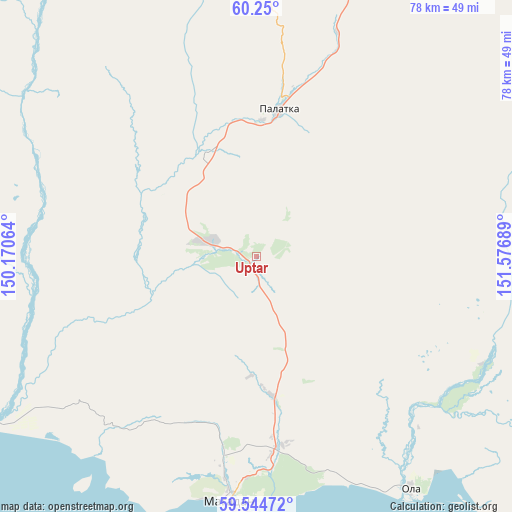
Uptar GPS coordinates[2]
59° 53' 57.228" North, 150° 52' 25.536" East
| Map corner | latitude | longitude |
|---|---|---|
| Upper-left | 60.25°, | 150.17064° |
| Center: | 59.89923°, | 150.87376° |
| Lower-right: | 59.54472°, | 151.57689° |
| Map W x H: | 78.4×78.4 km | = 48.7×48.7mi |
| max Lat: | 73.50819° ⇑10.5% North |
| Uptar: | 59.89923° |
| min Lat: | ⇓89.5% South 41.28413° |
| min Long | Uptar | max Long |
| -179.12198° | 150.87376° | 179.35046° |
| W 99.3%⇐ | ⇒0.7% E |
Elevation
Elevation of Uptar is 217 m = 712 ft, and this is 14.4 m = 47 ft above average elevation for this country.
| Max E: |
2518 m = 8261 ft | 25% |
| Uptar | 217 m 712 ft | |
| Avg. | 202.6 m = 665 ft | |
Min E: |
-28 m = -92 ft | 75% |
See also: Russia elevation on elevation.city.
Geographical zone
Uptar is located in North temperate zone (between Tropic of Cancer and the Arctic Circle). Distance of this North polar circle is 741 km =460.4 mi to North.| Distance of | km | miles | from Uptar |
|---|---|---|---|
| North Pole | 3346.9 | 2079.7 | to North |
| Arctic Circle | 741 | 460.4 | to North |
| Tropic Cancer | 4054.3 | 2519.2 | to South |
| Equator | 6660.2 | 4138.5 | to South |


Nearby cities:
15 places around Uptar: (largest is in red/bold)
• Arman’
48.7 km =30.3 mi,  238°
238°
• Atka
115.6 km =71.8 mi,  25°
25°
• Burkhala
319.8 km =198.7 mi,  342°
342°
• Debin
271.7 km =168.8 mi,  358°
358°
• Karamken
36.6 km =22.7 mi,  19°
19°
• Magadan
37.5 km =23.3 mi,  186°
186°
• Ola
42.9 km =26.7 mi,  146°
146°
• Orotukan
266.4 km =165.5 mi,  9°
9°
• Palatka
22.8 km =14.2 mi, 8°
• Sinegor'ye
244.1 km =151.7 mi, 355°
• Sokol
7.2 km =4.5 mi,  287°
287°
• Spornoye
271.8 km =168.9 mi,  2°
2°
• Talaya
193.5 km =120.2 mi, 32°
• Ust’-Omchug
153.1 km =95.1 mi,  333°
333°
• Yagodnoye
299.4 km =186 mi,  347°
347°
Sources, notices
• [Note1] Compared only with cities in Russia existing in our database
• [Src1] Map data: © OpenStreetMap contributors (CC-BY-SA)
• [Src2] Other city data from geonames.org with taken over terms of usage.
• [Src3] Geographical zone / Annual Mean Temperature by Robert A. Rohde @ Wikipedia
