Arman’ geodata
Arman’ (Magadan Oblast) is a populated place; located in Russia in Asia/Magadan (GMT+11) time zone. With population of 1,411 people, there are 4424 cities with bigger population in this country. Compared to other cities in Russia, 88.5% of cities are located further ↓South; 99.2% of cities are located further ←West and 97.6% of cities have higher elevation than Arman’. Note1


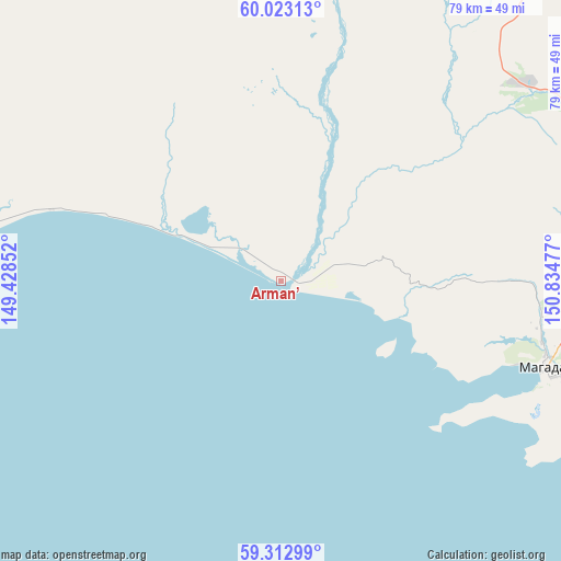
Arman’ GPS coordinates[2]
59° 40' 11.784" North, 150° 7' 53.904" East
| Map corner | latitude | longitude |
|---|---|---|
| Upper-left | 60.02313°, | 149.42852° |
| Center: | 59.66994°, | 150.13164° |
| Lower-right: | 59.31299°, | 150.83477° |
| Map W x H: | 79×79 km | = 49.1×49.1mi |
| max Lat: | 73.50819° ⇑11.5% North |
| Arman’: | 59.66994° |
| min Lat: | ⇓88.5% South 41.28413° |
| min Long | Arman’ | max Long |
| -179.12198° | 150.13164° | 179.35046° |
| W 99.2%⇐ | ⇒0.8% E |
Elevation
Elevation of Arman’ is 6 m = 20 ft, and this is 196.6 m = 645 ft below average elevation for this country.
| Max E: |
2518 m = 8261 ft | 97.6% |
| Avg. | 202.6 m = 665 ft | |
| Arman’ | 6 m = 20 ft | |
Min E: |
-28 m = -92 ft | 2.4% |
See also: Russia elevation on elevation.city.
Geographical zone
Arman’ is located in North temperate zone (between Tropic of Cancer and the Arctic Circle). Distance of this North polar circle is 766.5 km =476.3 mi to North.| Distance of | km | miles | from Arman’ |
|---|---|---|---|
| North Pole | 3372.4 | 2095.5 | to North |
| Arctic Circle | 766.5 | 476.3 | to North |
| Tropic Cancer | 4028.8 | 2503.4 | to South |
| Equator | 6634.7 | 4122.6 | to South |


Nearby cities:
15 places around Arman’: (largest is in red/bold)
• Atka
158.6 km =98.5 mi,  35°
35°
• Burkhala
335.6 km =208.5 mi,  350°
350°
• Debin
299 km =185.8 mi,  6°
6°
• Karamken
80.4 km =50 mi, 41°
• Magadan
39.6 km =24.6 mi,  107°
107°
• Ola
66.4 km =41.3 mi,  98°
98°
• Orotukan
300.2 km =186.5 mi,  16°
16°
• Palatka
65.7 km =40.8 mi, 42°
• Sinegor'ye
269.7 km =167.6 mi,  4°
4°
• Sokol
44.2 km =27.5 mi,  51°
51°
• Spornoye
301.6 km =187.4 mi, 10°
• Talaya
237.8 km =147.8 mi, 37°
• Uptar
48.7 km =30.3 mi,  58°
58°
• Ust’-Omchug
165 km =102.5 mi, 350°
• Yagodnoye
318.5 km =197.9 mi,  355°
355°
Sources, notices
• [Note1] Compared only with cities in Russia existing in our database
• [Src1] Map data: © OpenStreetMap contributors (CC-BY-SA)
• [Src2] Other city data from geonames.org with taken over terms of usage.
• [Src3] Geographical zone / Annual Mean Temperature by Robert A. Rohde @ Wikipedia
